Susa geodata
Susa (Cundinamarca) is a seat of a second-order administrative division; located in Colombia in America/Bogota (GMT-5) time zone. With population of 1,608 people, there are 852 cities with bigger population in this country. Compared to other cities in Colombia, 51.6% of cities are located further ↑North; 69.5% of cities are located further ←West and 90.8% of cities have lower elevation than Susa. Note1


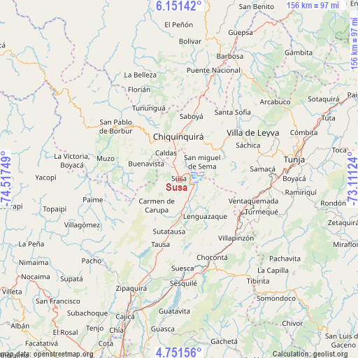
Susa GPS coordinates[2]
5° 27' 6.84" North, 73° 48' 51.696" West
| Map corner | latitude | longitude |
|---|---|---|
| Upper-left | 6.15142°, | -74.51749° |
| Center: | 5.4519°, | -73.81436° |
| Lower-right: | 4.75156°, | -73.11124° |
| Map W x H: | 155.6×155.7 km | = 96.7×96.7mi |
| max Lat: | 13.38166° ⇑51.6% North |
| Susa: | 5.4519° |
| min Lat: | ⇓48.4% South -4.21528° |
| min Long | Susa | max Long |
| -81.70636° | -73.81436° | -67.06996° |
| W 69.5%⇐ | ⇒30.5% E |
Elevation
Elevation of Susa is 2561 m = 8402 ft, and this is 1411.7 m = 4632 ft above average elevation for this country.
| Max E: |
3342 m = 10965 ft | 9.2% |
| Susa | 2561 m 8402 ft | |
| Avg. | 1149.3 m = 3771 ft | |
Min E: |
1 m = 3 ft | 90.8% |
See also: Colombia elevation on elevation.city.
Geographical zone
Susa is located in North Torrid zone (between Equator and Tropic of Cancer). Distance of Equator is 606.2 km =376.7 mi to South.| Distance of | km | miles | from Susa |
|---|---|---|---|
| North Pole | 9400.9 | 5841.4 | to North |
| Arctic Circle | 6795 | 4222.2 | to North |
| Tropic Cancer | 1999.7 | 1242.6 | to North |
| Equator | 606.2 | 376.7 | to South |


Nearby cities:
15 places around Susa: (largest is in red/bold)
• Buenavista
16.4 km =10.2 mi,  294°
294°
• Caldas
12.7 km =7.9 mi,  333°
333°
• Carmen de Carupa
15 km =9.3 mi,  220°
220°
• Chiquinquirá
18.3 km =11.4 mi,  358°
358°
• Cucunubá
23.1 km =14.4 mi,  166°
166°
• Fúquene
5.7 km =3.5 mi,  159°
159°
• Guachetá
16.1 km =10 mi,  117°
117°
• La Mesa
23.5 km =14.6 mi,  208°
208°
• Lenguazaque
19.7 km =12.2 mi,  144°
144°
• Ráquira
22.3 km =13.9 mi,  64°
64°
• San Miguel de Sema
12.6 km =7.8 mi,  53°
53°
• Simijaca
7.1 km =4.4 mi,  323°
323°
• Sutatausa
23.1 km =14.4 mi,  190°
190°
• Tinjacá
23.5 km =14.6 mi, 52°
• Villa de San Diego de Ubaté
15.9 km =9.9 mi,  180°
180°
Sources, notices
• [Note1] Compared only with cities in Colombia existing in our database
• [Src1] Map data: © OpenStreetMap contributors (CC-BY-SA)
• [Src2] Other city data from geonames.org with taken over terms of usage.
• [Src3] Geographical zone / Annual Mean Temperature by Robert A. Rohde @ Wikipedia
