Piedecuesta geodata
Piedecuesta (Santander) is a seat of a second-order administrative division; located in Colombia in America/Bogota (GMT-5) time zone. With population of 86,387 people, there are 48 cities with bigger population in this country. Compared to other cities in Colombia, 74% of cities are located further ↓South; 85.6% of cities are located further ←West and 53% of cities have higher elevation than Piedecuesta. Note1


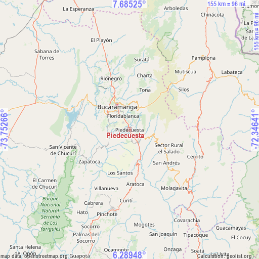
Piedecuesta GPS coordinates[2]
6° 59' 16.404" North, 73° 2' 58.308" West
| Map corner | latitude | longitude |
|---|---|---|
| Upper-left | 7.68525°, | -73.75266° |
| Center: | 6.98789°, | -73.04953° |
| Lower-right: | 6.28948°, | -72.34641° |
| Map W x H: | 155.2×155.2 km | = 96.4×96.4mi |
| max Lat: | 13.38166° ⇑26% North |
| Piedecuesta: | 6.98789° |
| min Lat: | ⇓74% South -4.21528° |
| min Long | Piedecuesta | max Long |
| -81.70636° | -73.04953° | -67.06996° |
| W 85.6%⇐ | ⇒14.4% E |
Elevation
Elevation of Piedecuesta is 1014 m = 3327 ft, and this is 135.3 m = 444 ft below average elevation for this country.
| Max E: |
3342 m = 10965 ft | 53% |
| Avg. | 1149.3 m = 3771 ft | |
| Piedecuesta | 1014 m = 3327 ft | |
Min E: |
1 m = 3 ft | 47% |
See also: Piedecuesta elevation on elevation.city.
Geographical zone
Piedecuesta is located in North Torrid zone (between Equator and Tropic of Cancer). Distance of Equator is 777 km =482.8 mi to South.| Distance of | km | miles | from Piedecuesta |
|---|---|---|---|
| North Pole | 9230.1 | 5735.3 | to North |
| Arctic Circle | 6624.2 | 4116.1 | to North |
| Tropic Cancer | 1828.9 | 1136.4 | to North |
| Equator | 777 | 482.8 | to South |


Nearby cities:
15 places around Piedecuesta: (largest is in red/bold)
• Betulia
27.6 km =17.1 mi,  249°
249°
• Bucaramanga
17.1 km =10.6 mi,  333°
333°
• Cepitá
27.3 km =17 mi,  162°
162°
• Floridablanca
9.2 km =5.7 mi, 333°
• Girón
16 km =9.9 mi,  303°
303°
• Guaca
24.7 km =15.3 mi,  120°
120°
• Jordán
28.8 km =17.9 mi,  190°
190°
• Lebrija
23.2 km =14.4 mi,  306°
306°
• Los Santos
20.8 km =12.9 mi,  346°
346°
• Los Santos
26.8 km =16.7 mi, 193°
• Rionegro
32.7 km =20.3 mi,  340°
340°
• San Andrés
29.6 km =18.4 mi,  131°
131°
• Santa Bárbara
15.7 km =9.8 mi,  89°
89°
• Tona
25.6 km =15.9 mi,  21°
21°
• Zapatoca
30.8 km =19.1 mi,  231°
231°
Sources, notices
• [Note1] Compared only with cities in Colombia existing in our database
• [Src1] Map data: © OpenStreetMap contributors (CC-BY-SA)
• [Src2] Other city data from geonames.org with taken over terms of usage.
• [Src3] Geographical zone / Annual Mean Temperature by Robert A. Rohde @ Wikipedia
