Girón geodata
Girón (Santander) is a seat of a second-order administrative division; located in Colombia in America/Bogota (GMT-5) time zone. With population of 108,466 people, there are 37 cities with bigger population in this country. Compared to other cities in Colombia, 74.9% of cities are located further ↓South; 83.5% of cities are located further ←West and 60.4% of cities have higher elevation than Girón. Note1


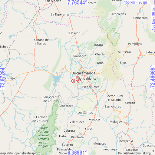
Girón GPS coordinates[2]
7° 4' 5.52" North, 73° 10' 11.316" West
| Map corner | latitude | longitude |
|---|---|---|
| Upper-left | 7.76544°, | -73.87294° |
| Center: | 7.0682°, | -73.16981° |
| Lower-right: | 6.36991°, | -72.46669° |
| Map W x H: | 155.2×155.2 km | = 96.4×96.4mi |
| max Lat: | 13.38166° ⇑25.1% North |
| Girón: | 7.0682° |
| min Lat: | ⇓74.9% South -4.21528° |
| min Long | Girón | max Long |
| -81.70636° | -73.16981° | -67.06996° |
| W 83.5%⇐ | ⇒16.5% E |
Elevation
Elevation of Girón is 706 m = 2316 ft, and this is 443.3 m = 1454 ft below average elevation for this country.
| Max E: |
3342 m = 10965 ft | 60.4% |
| Avg. | 1149.3 m = 3771 ft | |
| Girón | 706 m = 2316 ft | |
Min E: |
1 m = 3 ft | 39.6% |
See also: Girón elevation on elevation.city.
Geographical zone
Girón is located in North Torrid zone (between Equator and Tropic of Cancer). Distance of Equator is 785.9 km =488.3 mi to South.| Distance of | km | miles | from Girón |
|---|---|---|---|
| North Pole | 9221.2 | 5729.8 | to North |
| Arctic Circle | 6615.3 | 4110.6 | to North |
| Tropic Cancer | 1820 | 1130.9 | to North |
| Equator | 785.9 | 488.3 | to South |


Nearby cities:
15 places around Girón: (largest is in red/bold)
• Betulia
22.5 km =14 mi,  213°
213°
• Bucaramanga
8.4 km =5.2 mi,  40°
40°
• Charta
32.4 km =20.1 mi, 43°
• Floridablanca
9.2 km =5.7 mi,  94°
94°
• Jordán
38.2 km =23.7 mi,  167°
167°
• Lebrija
7.3 km =4.5 mi,  313°
313°
• Los Santos
14.1 km =8.8 mi, 36°
• Los Santos
35.7 km =22.2 mi, 168°
• Matanza
33 km =20.5 mi,  31°
31°
• Piedecuesta
16 km =9.9 mi,  123°
123°
• Rionegro
21.9 km =13.6 mi,  5°
5°
• San Vicente de Chucurí
33.7 km =20.9 mi,  231°
231°
• Santa Bárbara
30.3 km =18.8 mi,  106°
106°
• Tona
27.1 km =16.8 mi,  56°
56°
• Zapatoca
30.1 km =18.7 mi,  201°
201°
Sources, notices
• [Note1] Compared only with cities in Colombia existing in our database
• [Src1] Map data: © OpenStreetMap contributors (CC-BY-SA)
• [Src2] Other city data from geonames.org with taken over terms of usage.
• [Src3] Geographical zone / Annual Mean Temperature by Robert A. Rohde @ Wikipedia
