Santa Bárbara geodata
Santa Bárbara (Santander) is a seat of a second-order administrative division; located in Colombia in America/Bogota (GMT-5) time zone. With population of 291 people, there are 1046 cities with bigger population in this country. Compared to other cities in Colombia, 74.1% of cities are located further ↓South; 88.5% of cities are located further ←West and 76.7% of cities have lower elevation than Santa Bárbara. Note1


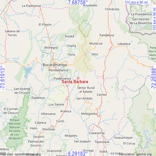
Santa Bárbara GPS coordinates[2]
6° 59' 24.792" North, 72° 54' 25.2" West
| Map corner | latitude | longitude |
|---|---|---|
| Upper-left | 7.68758°, | -73.61013° |
| Center: | 6.99022°, | -72.907° |
| Lower-right: | 6.29182°, | -72.20388° |
| Map W x H: | 155.2×155.2 km | = 96.4×96.4mi |
| max Lat: | 13.38166° ⇑25.9% North |
| Santa Bárbara: | 6.99022° |
| min Lat: | ⇓74.1% South -4.21528° |
| min Long | Santa Bárbara | max Long |
| -81.70636° | -72.907° | -67.06996° |
| W 88.5%⇐ | ⇒11.5% E |
Elevation
Elevation of Santa Bárbara is 1913 m = 6276 ft, and this is 763.7 m = 2506 ft above average elevation for this country.
| Max E: |
3342 m = 10965 ft | 23.3% |
| Santa Bárbara | 1913 m 6276 ft | |
| Avg. | 1149.3 m = 3771 ft | |
Min E: |
1 m = 3 ft | 76.7% |
See also: Colombia elevation on elevation.city.
Geographical zone
Santa Bárbara is located in North Torrid zone (between Equator and Tropic of Cancer). Distance of Equator is 777.2 km =482.9 mi to South.| Distance of | km | miles | from Santa Bárbara |
|---|---|---|---|
| North Pole | 9229.8 | 5735.1 | to North |
| Arctic Circle | 6623.9 | 4115.9 | to North |
| Tropic Cancer | 1828.7 | 1136.3 | to North |
| Equator | 777.2 | 482.9 | to South |


Nearby cities:
15 places around Santa Bárbara: (largest is in red/bold)
• Bucaramanga
27.9 km =17.3 mi,  302°
302°
• Cepitá
27.3 km =17 mi,  195°
195°
• Cerrito
28.6 km =17.8 mi,  124°
124°
• Charta
32.9 km =20.4 mi,  348°
348°
• Chitagá
31.4 km =19.5 mi,  58°
58°
• Concepción
34.3 km =21.3 mi,  136°
136°
• Floridablanca
21.4 km =13.3 mi,  292°
292°
• Girón
30.3 km =18.8 mi, 286°
• Guaca
13.9 km =8.6 mi,  156°
156°
• Los Santos
28.7 km =17.8 mi,  314°
314°
• Los Santos
34.2 km =21.3 mi,  219°
219°
• Piedecuesta
15.7 km =9.8 mi,  269°
269°
• San Andrés
20.9 km =13 mi, 162°
• Silos
29.1 km =18.1 mi,  34°
34°
• Tona
24.4 km =15.2 mi,  344°
344°
Sources, notices
• [Note1] Compared only with cities in Colombia existing in our database
• [Src1] Map data: © OpenStreetMap contributors (CC-BY-SA)
• [Src2] Other city data from geonames.org with taken over terms of usage.
• [Src3] Geographical zone / Annual Mean Temperature by Robert A. Rohde @ Wikipedia
