Sácama geodata
Sácama (Casanare) is a seat of a second-order administrative division; located in Colombia in America/Bogota (GMT-5) time zone. With population of 743 people, there are 992 cities with bigger population in this country. Compared to other cities in Colombia, 61.1% of cities are located further ↓South; 97.3% of cities are located further ←West and 53.5% of cities have lower elevation than Sácama. Note1


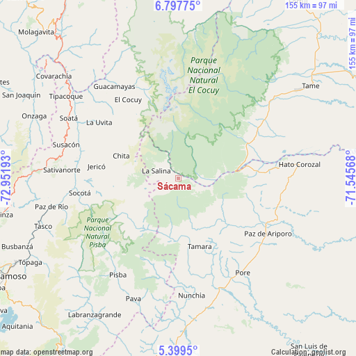
Sácama GPS coordinates[2]
6° 5' 56.688" North, 72° 14' 55.68" West
| Map corner | latitude | longitude |
|---|---|---|
| Upper-left | 6.79775°, | -72.95193° |
| Center: | 6.09908°, | -72.2488° |
| Lower-right: | 5.3995°, | -71.54568° |
| Map W x H: | 155.5×155.5 km | = 96.6×96.6mi |
| max Lat: | 13.38166° ⇑38.9% North |
| Sácama: | 6.09908° |
| min Lat: | ⇓61.1% South -4.21528° |
| min Long | Sácama | max Long |
| -81.70636° | -72.2488° | -67.06996° |
| W 97.3%⇐ | ⇒2.7% E |
Elevation
Elevation of Sácama is 1248 m = 4094 ft, and this is 98.7 m = 324 ft above average elevation for this country.
| Max E: |
3342 m = 10965 ft | 46.5% |
| Sácama | 1248 m 4094 ft | |
| Avg. | 1149.3 m = 3771 ft | |
Min E: |
1 m = 3 ft | 53.5% |
See also: Colombia elevation on elevation.city.
Geographical zone
Sácama is located in North Torrid zone (between Equator and Tropic of Cancer). Distance of Equator is 678.2 km =421.4 mi to South.| Distance of | km | miles | from Sácama |
|---|---|---|---|
| North Pole | 9328.9 | 5796.7 | to North |
| Arctic Circle | 6723 | 4177.5 | to North |
| Tropic Cancer | 1927.8 | 1197.9 | to North |
| Equator | 678.2 | 421.4 | to South |


Nearby cities:
15 places around Sácama: (largest is in red/bold)
• Boavita
45.2 km =28.1 mi,  304°
304°
• Chita
27.1 km =16.8 mi,  292°
292°
• El Cocuy
41.2 km =25.6 mi,  327°
327°
• Guacamayas
49.3 km =30.6 mi, 325°
• Güicán
44.7 km =27.8 mi,  335°
335°
• Jericó
36 km =22.4 mi,  278°
278°
• La Salina
10.5 km =6.5 mi, 290°
• La Uvita
42.6 km =26.5 mi,  305°
305°
• Panqueba
45.2 km =28.1 mi, 328°
• Paz de Ariporo
46.3 km =28.8 mi,  121°
121°
• Pisba
49.3 km =30.6 mi,  212°
212°
• Pore
50.1 km =31.1 mi,  145°
145°
• San Mateo
47.6 km =29.6 mi,  315°
315°
• Socotá
43.2 km =26.8 mi,  261°
261°
• Támara
31.4 km =19.5 mi,  162°
162°
Sources, notices
• [Note1] Compared only with cities in Colombia existing in our database
• [Src1] Map data: © OpenStreetMap contributors (CC-BY-SA)
• [Src2] Other city data from geonames.org with taken over terms of usage.
• [Src3] Geographical zone / Annual Mean Temperature by Robert A. Rohde @ Wikipedia
