Cachipay geodata
Cachipay (Cundinamarca) is a populated place; located in Colombia in America/Bogota (GMT-5) time zone. With population of 4,260 people, there are 557 cities with bigger population in this country. Compared to other cities in Colombia, 55.9% of cities are located further ↑North; 55.5% of cities are located further ←West and 66.6% of cities have higher elevation than Cachipay. Note1


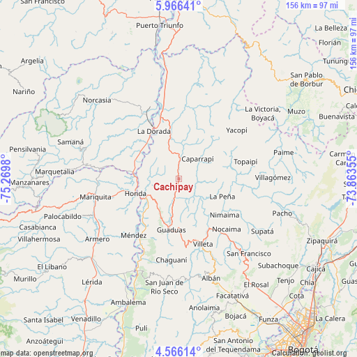
Cachipay GPS coordinates[2]
5° 16' 0.012" North, 74° 34' 0.012" West
| Map corner | latitude | longitude |
|---|---|---|
| Upper-left | 5.96641°, | -75.2698° |
| Center: | 5.26667°, | -74.56667° |
| Lower-right: | 4.56614°, | -73.86355° |
| Map W x H: | 155.7×155.7 km | = 96.7×96.7mi |
| max Lat: | 13.38166° ⇑55.9% North |
| Cachipay: | 5.26667° |
| min Lat: | ⇓44.1% South -4.21528° |
| min Long | Cachipay | max Long |
| -81.70636° | -74.56667° | -67.06996° |
| W 55.5%⇐ | ⇒44.5% E |
Elevation
Elevation of Cachipay is 389 m = 1276 ft, and this is 760.3 m = 2494 ft below average elevation for this country.
| Max E: |
3342 m = 10965 ft | 66.6% |
| Avg. | 1149.3 m = 3771 ft | |
| Cachipay | 389 m = 1276 ft | |
Min E: |
1 m = 3 ft | 33.4% |
See also: Colombia elevation on elevation.city.
Geographical zone
Cachipay is located in North Torrid zone (between Equator and Tropic of Cancer). Distance of Equator is 585.6 km =363.9 mi to South.| Distance of | km | miles | from Cachipay |
|---|---|---|---|
| North Pole | 9421.5 | 5854.2 | to North |
| Arctic Circle | 6815.6 | 4235 | to North |
| Tropic Cancer | 2020.3 | 1255.4 | to North |
| Equator | 585.6 | 363.9 | to South |


Nearby cities:
15 places around Cachipay: (largest is in red/bold)
• Caparrapí
12.2 km =7.6 mi,  43°
43°
• Granada
22.2 km =13.8 mi,  180°
180°
• Guaduas
22.4 km =13.9 mi,  188°
188°
• Honda
19.8 km =12.3 mi,  250°
250°
• La Dorada
22.8 km =14.2 mi,  332°
332°
• La Palma
22.1 km =13.7 mi,  62°
62°
• La Peña
20.6 km =12.8 mi,  111°
111°
• Nimaima
25.5 km =15.8 mi,  127°
127°
• Nocaima
30 km =18.6 mi,  137°
137°
• Puerto Bogotá
19.3 km =12 mi, 247°
• Puerto Salgar
23.9 km =14.9 mi,  336°
336°
• Quebradanegra
19.2 km =11.9 mi,  149°
149°
• Topaipí
30.2 km =18.8 mi,  75°
75°
• Vergara
29.5 km =18.3 mi,  123°
123°
• Útica
13 km =8.1 mi, 132°
Sources, notices
• [Note1] Compared only with cities in Colombia existing in our database
• [Src1] Map data: © OpenStreetMap contributors (CC-BY-SA)
• [Src2] Other city data from geonames.org with taken over terms of usage.
• [Src3] Geographical zone / Annual Mean Temperature by Robert A. Rohde @ Wikipedia
