Puerto Salgar geodata
Puerto Salgar (Cundinamarca) is a seat of a second-order administrative division; located in Colombia in America/Bogota (GMT-5) time zone. With population of 9,863 people, there are 311 cities with bigger population in this country. Compared to other cities in Colombia, 51.2% of cities are located further ↑North; 54% of cities are located further ←West and 75.4% of cities have higher elevation than Puerto Salgar. Note1


Puerto Salgar GPS coordinates[2]
5° 27' 46.944" North, 74° 39' 15.696" West
| Map corner | latitude | longitude |
|---|---|---|
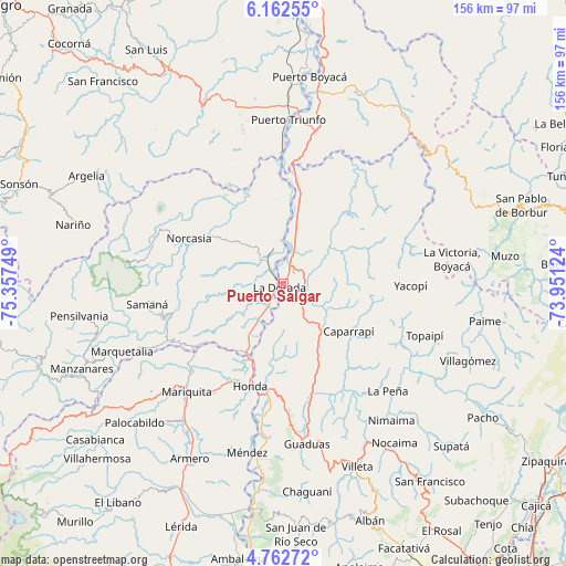
| Upper-left | 6.16255°, | -75.35749° |
| Center: | 5.46304°, | -74.65436° |
| Lower-right: | 4.76272°, | -73.95124° |
| Map W x H: | 155.6×155.7 km | = 96.7×96.7mi |
| max Lat: | 13.38166° ⇑51.2% North |
| Puerto Salgar: | 5.46304° |
| min Lat: | ⇓48.8% South -4.21528° |
| min Long | Puerto Salgar | max Long |
| -81.70636° | -74.65436° | -67.06996° |
| W 54%⇐ | ⇒46% E |
Elevation
Elevation of Puerto Salgar is 177 m = 581 ft, and this is 972.3 m = 3190 ft below average elevation for this country.
| Max E: |
3342 m = 10965 ft | 75.4% |
| Avg. | 1149.3 m = 3771 ft | |
| Puerto Salgar | 177 m = 581 ft | |
Min E: |
1 m = 3 ft | 24.6% |
See also: Colombia elevation on elevation.city.
Geographical zone
Puerto Salgar is located in North Torrid zone (between Equator and Tropic of Cancer). Distance of Equator is 607.4 km =377.4 mi to South.| Distance of | km | miles | from Puerto Salgar |
|---|---|---|---|
| North Pole | 9399.6 | 5840.6 | to North |
| Arctic Circle | 6793.7 | 4221.4 | to North |
| Tropic Cancer | 1998.5 | 1241.8 | to North |
| Equator | 607.4 | 377.4 | to South |


Nearby cities:
15 places around Puerto Salgar: (largest is in red/bold)
• Cachipay
23.9 km =14.9 mi,  156°
156°
• Caparrapí
22.2 km =13.8 mi,  125°
125°
• Honda
29.7 km =18.5 mi,  197°
197°
• La Dorada
1.9 km =1.2 mi,  209°
209°
• La Palma
31.4 km =19.5 mi,  111°
111°
• La Peña
41.2 km =25.6 mi,  135°
135°
• Norcasia
28.7 km =17.8 mi,  295°
295°
• Puerto Bogotá
30.3 km =18.8 mi, 195°
• Quebradanegra
43 km =26.7 mi,  153°
153°
• Samaná
37.8 km =23.5 mi,  261°
261°
• San Sebastián de Mariquita
39.5 km =24.5 mi,  221°
221°
• Topaipí
41.4 km =25.7 mi, 110°
• Victoria
32.8 km =20.4 mi,  240°
240°
• Yacopí
35 km =21.7 mi,  90°
90°
• Útica
36.2 km =22.5 mi, 147°
Sources, notices
• [Note1] Compared only with cities in Colombia existing in our database
• [Src1] Map data: © OpenStreetMap contributors (CC-BY-SA)
• [Src2] Other city data from geonames.org with taken over terms of usage.
• [Src3] Geographical zone / Annual Mean Temperature by Robert A. Rohde @ Wikipedia
