Cumaral geodata
Cumaral (Meta) is a seat of a second-order administrative division; located in Colombia in America/Bogota (GMT-5) time zone. With population of 11,263 people, there are 271 cities with bigger population in this country. Compared to other cities in Colombia, 75.3% of cities are located further ↑North; 75.9% of cities are located further ←West and 65.9% of cities have higher elevation than Cumaral. Note1


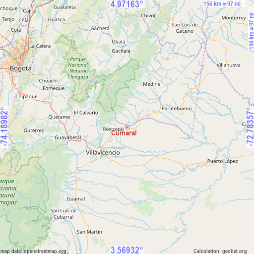
Cumaral GPS coordinates[2]
4° 16' 14.88" North, 73° 29' 12.084" West
| Map corner | latitude | longitude |
|---|---|---|
| Upper-left | 4.97163°, | -74.18982° |
| Center: | 4.2708°, | -73.48669° |
| Lower-right: | 3.56932°, | -72.78357° |
| Map W x H: | 155.9×155.9 km | = 96.9×96.9mi |
| max Lat: | 13.38166° ⇑75.3% North |
| Cumaral: | 4.2708° |
| min Lat: | ⇓24.7% South -4.21528° |
| min Long | Cumaral | max Long |
| -81.70636° | -73.48669° | -67.06996° |
| W 75.9%⇐ | ⇒24.1% E |
Elevation
Elevation of Cumaral is 412 m = 1352 ft, and this is 737.3 m = 2419 ft below average elevation for this country.
| Max E: |
3342 m = 10965 ft | 65.9% |
| Avg. | 1149.3 m = 3771 ft | |
| Cumaral | 412 m = 1352 ft | |
Min E: |
1 m = 3 ft | 34.1% |
See also: Colombia elevation on elevation.city.
Geographical zone
Cumaral is located in North Torrid zone (between Equator and Tropic of Cancer). Distance of Equator is 474.9 km =295.1 mi to South.| Distance of | km | miles | from Cumaral |
|---|---|---|---|
| North Pole | 9532.2 | 5923 | to North |
| Arctic Circle | 6926.3 | 4303.8 | to North |
| Tropic Cancer | 2131.1 | 1324.2 | to North |
| Equator | 474.9 | 295.1 | to South |


Nearby cities:
15 places around Cumaral: (largest is in red/bold)
• Acacías
43.6 km =27.1 mi,  223°
223°
• Cáqueza
53.2 km =33.1 mi,  286°
286°
• El Calvario
26.6 km =16.5 mi, 290°
• Fosca
50.7 km =31.5 mi,  278°
278°
• Fómeque
51.5 km =32 mi,  297°
297°
• Gachalá
47 km =29.2 mi,  355°
355°
• Guamal
53.3 km =33.1 mi, 215°
• Guayabetal
37.2 km =23.1 mi,  260°
260°
• Medina
30.6 km =19 mi,  29°
29°
• Paratebueno
32.3 km =20.1 mi,  68°
68°
• Quetame
42.1 km =26.2 mi, 279°
• Restrepo
8.4 km =5.2 mi, 260°
• San Juanito
30.1 km =18.7 mi,  314°
314°
• Ubalá
52.9 km =32.9 mi,  354°
354°
• Villavicencio
21.1 km =13.1 mi,  227°
227°
Sources, notices
• [Note1] Compared only with cities in Colombia existing in our database
• [Src1] Map data: © OpenStreetMap contributors (CC-BY-SA)
• [Src2] Other city data from geonames.org with taken over terms of usage.
• [Src3] Geographical zone / Annual Mean Temperature by Robert A. Rohde @ Wikipedia
