Paratebueno geodata
Paratebueno (Cundinamarca) is a seat of a second-order administrative division; located in Colombia in America/Bogota (GMT-5) time zone. With population of 2,027 people, there are 795 cities with bigger population in this country. Compared to other cities in Colombia, 73.4% of cities are located further ↑North; 82.5% of cities are located further ←West and 71.7% of cities have higher elevation than Paratebueno. Note1


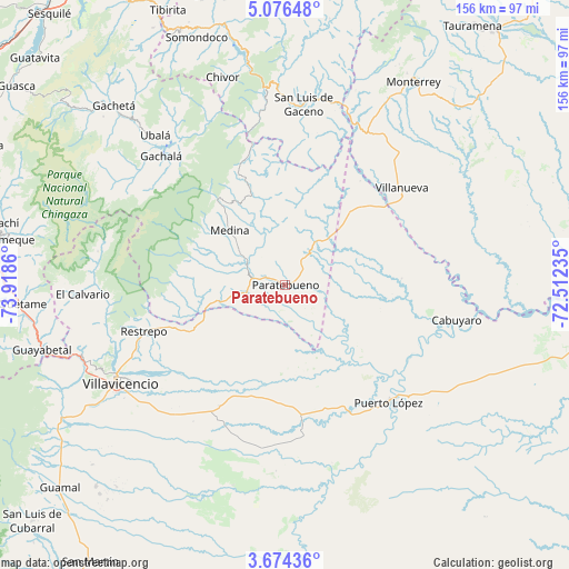
Paratebueno GPS coordinates[2]
4° 22' 32.7" North, 73° 12' 55.692" West
| Map corner | latitude | longitude |
|---|---|---|
| Upper-left | 5.07648°, | -73.9186° |
| Center: | 4.37575°, | -73.21547° |
| Lower-right: | 3.67436°, | -72.51235° |
| Map W x H: | 155.9×155.9 km | = 96.9×96.9mi |
| max Lat: | 13.38166° ⇑73.4% North |
| Paratebueno: | 4.37575° |
| min Lat: | ⇓26.6% South -4.21528° |
| min Long | Paratebueno | max Long |
| -81.70636° | -73.21547° | -67.06996° |
| W 82.5%⇐ | ⇒17.5% E |
Elevation
Elevation of Paratebueno is 262 m = 860 ft, and this is 887.3 m = 2911 ft below average elevation for this country.
| Max E: |
3342 m = 10965 ft | 71.7% |
| Avg. | 1149.3 m = 3771 ft | |
| Paratebueno | 262 m = 860 ft | |
Min E: |
1 m = 3 ft | 28.3% |
See also: Colombia elevation on elevation.city.
Geographical zone
Paratebueno is located in North Torrid zone (between Equator and Tropic of Cancer). Distance of Equator is 486.5 km =302.3 mi to South.| Distance of | km | miles | from Paratebueno |
|---|---|---|---|
| North Pole | 9520.5 | 5915.8 | to North |
| Arctic Circle | 6914.6 | 4296.5 | to North |
| Tropic Cancer | 2119.4 | 1316.9 | to North |
| Equator | 486.5 | 302.3 | to South |


Nearby cities:
15 places around Paratebueno: (largest is in red/bold)
• Barranca de Upía
35 km =21.7 mi,  51°
51°
• Cabuyaro
47.9 km =29.8 mi,  102°
102°
• Cumaral
32.3 km =20.1 mi,  248°
248°
• El Calvario
55 km =34.2 mi,  267°
267°
• Gachalá
48.8 km =30.3 mi,  316°
316°
• Medina
21.1 km =13.1 mi, 315°
• Puerto López
42.1 km =26.2 mi,  136°
136°
• Restrepo
40.5 km =25.2 mi, 251°
• Sabanalarga
56.7 km =35.2 mi,  20°
20°
• San Juanito
52.4 km =32.6 mi,  280°
280°
• San Luis de Gaceno
49.7 km =30.9 mi,  6°
6°
• Santa María
54.1 km =33.6 mi,  354°
354°
• Ubalá
54.1 km =33.6 mi, 319°
• Villanueva
41.3 km =25.7 mi, 50°
• Villavicencio
52.5 km =32.6 mi,  240°
240°
Sources, notices
• [Note1] Compared only with cities in Colombia existing in our database
• [Src1] Map data: © OpenStreetMap contributors (CC-BY-SA)
• [Src2] Other city data from geonames.org with taken over terms of usage.
• [Src3] Geographical zone / Annual Mean Temperature by Robert A. Rohde @ Wikipedia
