Lérida geodata
Lérida (Tolima) is a seat of a second-order administrative division; located in Colombia in America/Bogota (GMT-5) time zone. With population of 20,069 people, there are 179 cities with bigger population in this country. Compared to other cities in Colombia, 65.4% of cities are located further ↑North; 51.9% of cities are located further →East and 67.5% of cities have higher elevation than Lérida. Note1


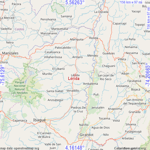
Lérida GPS coordinates[2]
4° 51' 44.712" North, 74° 54' 35.172" West
| Map corner | latitude | longitude |
|---|---|---|
| Upper-left | 5.56263°, | -75.6129° |
| Center: | 4.86242°, | -74.90977° |
| Lower-right: | 4.16148°, | -74.20665° |
| Map W x H: | 155.8×155.8 km | = 96.8×96.8mi |
| max Lat: | 13.38166° ⇑65.4% North |
| Lérida: | 4.86242° |
| min Lat: | ⇓34.6% South -4.21528° |
| min Long | Lérida | max Long |
| -81.70636° | -74.90977° | -67.06996° |
| W 48.1%⇐ | ⇒51.9% E |
Elevation
Elevation of Lérida is 345 m = 1132 ft, and this is 804.3 m = 2639 ft below average elevation for this country.
| Max E: |
3342 m = 10965 ft | 67.5% |
| Avg. | 1149.3 m = 3771 ft | |
| Lérida | 345 m = 1132 ft | |
Min E: |
1 m = 3 ft | 32.5% |
See also: Colombia elevation on elevation.city.
Geographical zone
Lérida is located in North Torrid zone (between Equator and Tropic of Cancer). Distance of Equator is 540.7 km =336 mi to South.| Distance of | km | miles | from Lérida |
|---|---|---|---|
| North Pole | 9466.4 | 5882.1 | to North |
| Arctic Circle | 6860.5 | 4262.9 | to North |
| Tropic Cancer | 2065.3 | 1283.3 | to North |
| Equator | 540.7 | 336 | to South |


Nearby cities:
15 places around Lérida: (largest is in red/bold)
• Ambalema
18.5 km =11.5 mi,  118°
118°
• Armero-Guyabal
11.7 km =7.3 mi,  3°
3°
• Beltrán
19.8 km =12.3 mi,  109°
109°
• Falan
29.4 km =18.3 mi,  350°
350°
• Frías
21.6 km =13.4 mi,  329°
329°
• Guayabal
18.9 km =11.7 mi,  7°
7°
• Junín
14.8 km =9.2 mi,  233°
233°
• Líbano
18.1 km =11.2 mi,  291°
291°
• Murillo
29 km =18 mi,  272°
272°
• Palocabildo
30.7 km =19.1 mi,  337°
337°
• Pulí
29.6 km =18.4 mi,  132°
132°
• San Juan de Rioseco
32 km =19.9 mi,  92°
92°
• Santa Isabel
26.6 km =16.5 mi, 231°
• Venadillo
16.1 km =10 mi,  187°
187°
• Villahermosa
29.5 km =18.3 mi,  309°
309°
Sources, notices
• [Note1] Compared only with cities in Colombia existing in our database
• [Src1] Map data: © OpenStreetMap contributors (CC-BY-SA)
• [Src2] Other city data from geonames.org with taken over terms of usage.
• [Src3] Geographical zone / Annual Mean Temperature by Robert A. Rohde @ Wikipedia
