Arboletes geodata
Arboletes (Antioquia) is a seat of a second-order administrative division; located in Colombia in America/Bogota (GMT-5) time zone. With population of 8,380 people, there are 355 cities with bigger population in this country. Compared to other cities in Colombia, 85.8% of cities are located further ↓South; 86.1% of cities are located further →East and 96.4% of cities have higher elevation than Arboletes. Note1


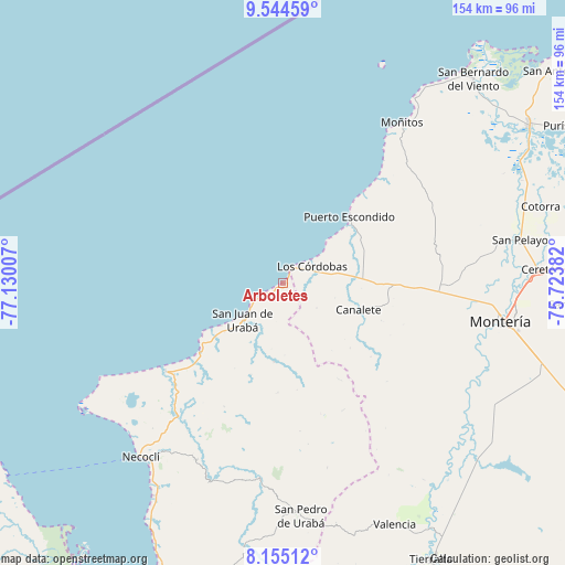
Arboletes GPS coordinates[2]
8° 51' 1.836" North, 76° 25' 36.984" West
| Map corner | latitude | longitude |
|---|---|---|
| Upper-left | 9.54459°, | -77.13007° |
| Center: | 8.85051°, | -76.42694° |
| Lower-right: | 8.15512°, | -75.72382° |
| Map W x H: | 154.5×154.5 km | = 96×96mi |
| max Lat: | 13.38166° ⇑14.2% North |
| Arboletes: | 8.85051° |
| min Lat: | ⇓85.8% South -4.21528° |
| min Long | Arboletes | max Long |
| -81.70636° | -76.42694° | -67.06996° |
| W 13.9%⇐ | ⇒86.1% E |
Elevation
Elevation of Arboletes is 10 m = 33 ft, and this is 1139.3 m = 3738 ft below average elevation for this country.
| Max E: |
3342 m = 10965 ft | 96.4% |
| Avg. | 1149.3 m = 3771 ft | |
| Arboletes | 10 m = 33 ft | |
Min E: |
1 m = 3 ft | 3.6% |
See also: Colombia elevation on elevation.city.
Geographical zone
Arboletes is located in North Torrid zone (between Equator and Tropic of Cancer). Distance of Equator is 984.1 km =611.5 mi to South.| Distance of | km | miles | from Arboletes |
|---|---|---|---|
| North Pole | 9023 | 5606.6 | to North |
| Arctic Circle | 6417.1 | 3987.4 | to North |
| Tropic Cancer | 1621.8 | 1007.7 | to North |
| Equator | 984.1 | 611.5 | to South |


Nearby cities:
15 places around Arboletes: (largest is in red/bold)
• Buenavista
51.6 km =32.1 mi,  64°
64°
• Canalete
21.7 km =13.5 mi,  109°
109°
• Canalete
31.2 km =19.4 mi,  128°
128°
• Cereté
70 km =43.5 mi,  86°
86°
• Cotorra
73.1 km =45.4 mi,  73°
73°
• Los Córdobas
9.3 km =5.8 mi, 58°
• Montería
61 km =37.9 mi,  100°
100°
• Moñitos
54.7 km =34 mi,  36°
36°
• Necoclí
61.7 km =38.3 mi,  220°
220°
• Puerto Escondido
25.8 km =16 mi, 43°
• San Bernardo del Viento
76.4 km =47.5 mi, 42°
• San Juan de Urabá
15.2 km =9.4 mi,  228°
228°
• San Pedro de Urabá
64.2 km =39.9 mi,  175°
175°
• San Pelayo
66 km =41 mi,  79°
79°
• Valencia
72.6 km =45.1 mi,  155°
155°
Sources, notices
• [Note1] Compared only with cities in Colombia existing in our database
• [Src1] Map data: © OpenStreetMap contributors (CC-BY-SA)
• [Src2] Other city data from geonames.org with taken over terms of usage.
• [Src3] Geographical zone / Annual Mean Temperature by Robert A. Rohde @ Wikipedia
