Necoclí geodata
Necoclí (Antioquia) is a seat of a second-order administrative division; located in Colombia in America/Bogota (GMT-5) time zone. With population of 10,835 people, there are 286 cities with bigger population in this country. Compared to other cities in Colombia, 83.3% of cities are located further ↓South; 90.6% of cities are located further →East and 99.2% of cities have higher elevation than Necoclí. Note1


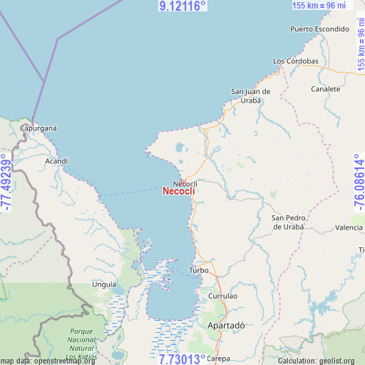
Necoclí GPS coordinates[2]
8° 25' 34.572" North, 76° 47' 21.336" West
| Map corner | latitude | longitude |
|---|---|---|
| Upper-left | 9.12116°, | -77.49239° |
| Center: | 8.42627°, | -76.78926° |
| Lower-right: | 7.73013°, | -76.08614° |
| Map W x H: | 154.7×154.7 km | = 96.1×96.1mi |
| max Lat: | 13.38166° ⇑16.7% North |
| Necoclí: | 8.42627° |
| min Lat: | ⇓83.3% South -4.21528° |
| min Long | Necoclí | max Long |
| -81.70636° | -76.78926° | -67.06996° |
| W 9.4%⇐ | ⇒90.6% E |
Elevation
Elevation of Necoclí is 4 m = 13 ft, and this is 1145.3 m = 3758 ft below average elevation for this country.
| Max E: |
3342 m = 10965 ft | 99.2% |
| Avg. | 1149.3 m = 3771 ft | |
| Necoclí | 4 m = 13 ft | |
Min E: |
1 m = 3 ft | 0.8% |
See also: Colombia elevation on elevation.city.
Geographical zone
Necoclí is located in North Torrid zone (between Equator and Tropic of Cancer). Distance of Equator is 936.9 km =582.2 mi to South.| Distance of | km | miles | from Necoclí |
|---|---|---|---|
| North Pole | 9070.1 | 5635.9 | to North |
| Arctic Circle | 6464.3 | 4016.7 | to North |
| Tropic Cancer | 1669 | 1037.1 | to North |
| Equator | 936.9 | 582.2 | to South |


Nearby cities:
15 places around Necoclí: (largest is in red/bold)
• Acandí
54.5 km =33.9 mi,  280°
280°
• Apartadó
63 km =39.1 mi,  163°
163°
• Arboletes
61.7 km =38.3 mi,  40°
40°
• Canalete
70.1 km =43.6 mi,  66°
66°
• Canalete
72.3 km =44.9 mi,  56°
56°
• Carepa
75.8 km =47.1 mi,  168°
168°
• Chigorodó
85.3 km =53 mi, 171°
• Los Córdobas
70.6 km =43.9 mi, 42°
• Moñitos
83.7 km =52 mi,  103°
103°
• San Juan de Urabá
46.7 km =29 mi, 37°
• San Pedro de Urabá
48.4 km =30.1 mi,  110°
110°
• Tierralta
85.1 km =52.9 mi, 109°
• Turbo
37.7 km =23.4 mi, 169°
• Unguía
54 km =33.6 mi,  218°
218°
• Valencia
72.8 km =45.2 mi, 104°
Sources, notices
• [Note1] Compared only with cities in Colombia existing in our database
• [Src1] Map data: © OpenStreetMap contributors (CC-BY-SA)
• [Src2] Other city data from geonames.org with taken over terms of usage.
• [Src3] Geographical zone / Annual Mean Temperature by Robert A. Rohde @ Wikipedia
