Algeciras geodata
Algeciras (Huila) is a populated place; located in Colombia in America/Bogota (GMT-5) time zone. With population of 10,792 people, there are 289 cities with bigger population in this country. Compared to other cities in Colombia, 86.8% of cities are located further ↑North; 62% of cities are located further →East and 53.4% of cities have higher elevation than Algeciras. Note1


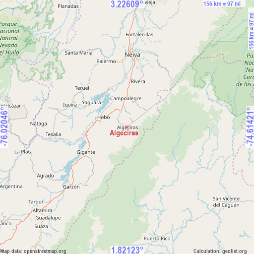
Algeciras GPS coordinates[2]
2° 31' 25.86" North, 75° 19' 2.388" West
| Map corner | latitude | longitude |
|---|---|---|
| Upper-left | 3.22609°, | -76.02046° |
| Center: | 2.52385°, | -75.31733° |
| Lower-right: | 1.82123°, | -74.61421° |
| Map W x H: | 156.2×156.2 km | = 97.1×97.1mi |
| max Lat: | 13.38166° ⇑86.8% North |
| Algeciras: | 2.52385° |
| min Lat: | ⇓13.2% South -4.21528° |
| min Long | Algeciras | max Long |
| -81.70636° | -75.31733° | -67.06996° |
| W 38%⇐ | ⇒62% E |
Elevation
Elevation of Algeciras is 995 m = 3264 ft, and this is 154.3 m = 506 ft below average elevation for this country.
| Max E: |
3342 m = 10965 ft | 53.4% |
| Avg. | 1149.3 m = 3771 ft | |
| Algeciras | 995 m = 3264 ft | |
Min E: |
1 m = 3 ft | 46.6% |
See also: Colombia elevation on elevation.city.
Geographical zone
Algeciras is located in North Torrid zone (between Equator and Tropic of Cancer). Distance of Equator is 280.6 km =174.4 mi to South.| Distance of | km | miles | from Algeciras |
|---|---|---|---|
| North Pole | 9726.4 | 6043.7 | to North |
| Arctic Circle | 7120.5 | 4424.5 | to North |
| Tropic Cancer | 2325.3 | 1444.9 | to North |
| Equator | 280.6 | 174.4 | to South |


Nearby cities:
15 places around Algeciras: (largest is in red/bold)
• Agrado
58.5 km =36.4 mi,  239°
239°
• Campoalegre
17.9 km =11.1 mi,  357°
357°
• Garzón
50.2 km =31.2 mi,  223°
223°
• Gigante
29.8 km =18.5 mi, 239°
• Hobo
16.2 km =10.1 mi,  294°
294°
• Neiva
45 km =28 mi,  5°
5°
• Nátaga
54.6 km =33.9 mi,  272°
272°
• Paicol
51.5 km =32 mi,  260°
260°
• Palermo
43 km =26.7 mi,  341°
341°
• Rivera
29 km =18 mi, 13°
• Santa María
55 km =34.2 mi,  327°
327°
• Teruel
36.9 km =22.9 mi,  311°
311°
• Tesalia
45.9 km =28.5 mi, 264°
• Yaguará
27.1 km =16.8 mi,  304°
304°
• Íquira
37.9 km =23.5 mi, 291°
Sources, notices
• [Note1] Compared only with cities in Colombia existing in our database
• [Src1] Map data: © OpenStreetMap contributors (CC-BY-SA)
• [Src2] Other city data from geonames.org with taken over terms of usage.
• [Src3] Geographical zone / Annual Mean Temperature by Robert A. Rohde @ Wikipedia
