Campoalegre geodata
Campoalegre (Huila) is a seat of a second-order administrative division; located in Colombia in America/Bogota (GMT-5) time zone. With population of 22,568 people, there are 162 cities with bigger population in this country. Compared to other cities in Colombia, 85.7% of cities are located further ↑North; 62.2% of cities are located further →East and 63.3% of cities have higher elevation than Campoalegre. Note1


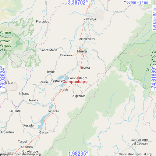
Campoalegre GPS coordinates[2]
2° 41' 5.604" North, 75° 19' 23.196" West
| Map corner | latitude | longitude |
|---|---|---|
| Upper-left | 3.38702°, | -76.02624° |
| Center: | 2.68489°, | -75.32311° |
| Lower-right: | 1.98235°, | -74.61999° |
| Map W x H: | 156.2×156.2 km | = 97.1×97.1mi |
| max Lat: | 13.38166° ⇑85.7% North |
| Campoalegre: | 2.68489° |
| min Lat: | ⇓14.3% South -4.21528° |
| min Long | Campoalegre | max Long |
| -81.70636° | -75.32311° | -67.06996° |
| W 37.8%⇐ | ⇒62.2% E |
Elevation
Elevation of Campoalegre is 537 m = 1762 ft, and this is 612.3 m = 2009 ft below average elevation for this country.
| Max E: |
3342 m = 10965 ft | 63.3% |
| Avg. | 1149.3 m = 3771 ft | |
| Campoalegre | 537 m = 1762 ft | |
Min E: |
1 m = 3 ft | 36.7% |
See also: Colombia elevation on elevation.city.
Geographical zone
Campoalegre is located in North Torrid zone (between Equator and Tropic of Cancer). Distance of Equator is 298.5 km =185.5 mi to South.| Distance of | km | miles | from Campoalegre |
|---|---|---|---|
| North Pole | 9708.5 | 6032.6 | to North |
| Arctic Circle | 7102.6 | 4413.3 | to North |
| Tropic Cancer | 2307.4 | 1433.8 | to North |
| Equator | 298.5 | 185.5 | to South |


Nearby cities:
15 places around Campoalegre: (largest is in red/bold)
• Algeciras
17.9 km =11.1 mi,  177°
177°
• Gigante
41.5 km =25.8 mi,  216°
216°
• Hobo
18.1 km =11.2 mi,  231°
231°
• Neiva
27.3 km =17 mi,  9°
9°
• Nátaga
56.2 km =34.9 mi,  253°
253°
• Paicol
56.6 km =35.2 mi,  242°
242°
• Palermo
26.3 km =16.3 mi,  331°
331°
• Rivera
12.7 km =7.9 mi,  35°
35°
• Santa María
40.6 km =25.2 mi,  314°
314°
• Santa María
46.8 km =29.1 mi, 309°
• Tello
47.2 km =29.3 mi,  25°
25°
• Teruel
27.9 km =17.3 mi,  283°
283°
• Tesalia
50.2 km =31.2 mi, 243°
• Yaguará
21.7 km =13.5 mi,  263°
263°
• Íquira
34.8 km =21.6 mi, 263°
Sources, notices
• [Note1] Compared only with cities in Colombia existing in our database
• [Src1] Map data: © OpenStreetMap contributors (CC-BY-SA)
• [Src2] Other city data from geonames.org with taken over terms of usage.
• [Src3] Geographical zone / Annual Mean Temperature by Robert A. Rohde @ Wikipedia
