Neiva geodata
Neiva (Huila) is a seat of a first-order administrative division; located in Colombia in America/Bogota (GMT-5) time zone. With population of 352,855 people, there are 13 cities with bigger population in this country. Compared to other cities in Colombia, 84.8% of cities are located further ↑North; 61.2% of cities are located further →East and 64.5% of cities have higher elevation than Neiva. Note1


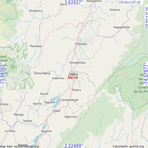
Neiva GPS coordinates[2]
2° 55' 38.28" North, 75° 16' 54.804" West
| Map corner | latitude | longitude |
|---|---|---|
| Upper-left | 3.62927°, | -75.98502° |
| Center: | 2.9273°, | -75.28189° |
| Lower-right: | 2.22489°, | -74.57877° |
| Map W x H: | 156.2×156.2 km | = 97.1×97.1mi |
| max Lat: | 13.38166° ⇑84.8% North |
| Neiva: | 2.9273° |
| min Lat: | ⇓15.2% South -4.21528° |
| min Long | Neiva | max Long |
| -81.70636° | -75.28189° | -67.06996° |
| W 38.8%⇐ | ⇒61.2% E |
Elevation
Elevation of Neiva is 461 m = 1512 ft, and this is 688.3 m = 2258 ft below average elevation for this country.
| Max E: |
3342 m = 10965 ft | 64.5% |
| Avg. | 1149.3 m = 3771 ft | |
| Neiva | 461 m = 1512 ft | |
Min E: |
1 m = 3 ft | 35.5% |
See also: Neiva elevation on elevation.city.
Geographical zone
Neiva is located in North Torrid zone (between Equator and Tropic of Cancer). Distance of Equator is 325.5 km =202.3 mi to South.| Distance of | km | miles | from Neiva |
|---|---|---|---|
| North Pole | 9681.6 | 6015.9 | to North |
| Arctic Circle | 7075.7 | 4396.6 | to North |
| Tropic Cancer | 2280.4 | 1417 | to North |
| Equator | 325.5 | 202.3 | to South |


Nearby cities:
15 places around Neiva: (largest is in red/bold)
• Aipe
33.2 km =20.6 mi,  8°
8°
• Algeciras
45 km =28 mi,  185°
185°
• Baraya
35.7 km =22.2 mi,  45°
45°
• Campoalegre
27.3 km =17 mi, 189°
• Hobo
42.6 km =26.5 mi,  206°
206°
• Palermo
17.7 km =11 mi,  257°
257°
• Planadas
50.3 km =31.3 mi,  306°
306°
• Rivera
16.9 km =10.5 mi,  170°
170°
• Santa María
33.8 km =21 mi,  272°
272°
• Santa María
41 km =25.5 mi, 273°
• Tello
22.3 km =13.9 mi, 45°
• Teruel
37.8 km =23.5 mi,  236°
236°
• Villavieja
33.4 km =20.8 mi, 12°
• Yaguará
39.3 km =24.4 mi,  221°
221°
• Íquira
49.9 km =31 mi,  231°
231°
Sources, notices
• [Note1] Compared only with cities in Colombia existing in our database
• [Src1] Map data: © OpenStreetMap contributors (CC-BY-SA)
• [Src2] Other city data from geonames.org with taken over terms of usage.
• [Src3] Geographical zone / Annual Mean Temperature by Robert A. Rohde @ Wikipedia
