Chaparral geodata
Chaparral (Tolima) is a seat of a second-order administrative division; located in Colombia in America/Bogota (GMT-5) time zone. With population of 19,982 people, there are 181 cities with bigger population in this country. Compared to other cities in Colombia, 80.1% of cities are located further ↑North; 66% of cities are located further →East and 58.6% of cities have higher elevation than Chaparral. Note1


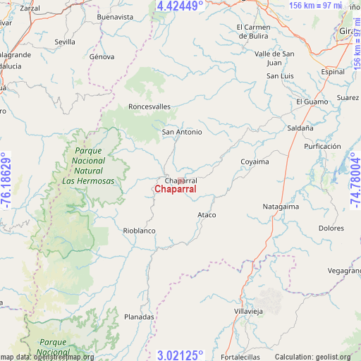
Chaparral GPS coordinates[2]
3° 43' 23.34" North, 75° 28' 59.376" West
| Map corner | latitude | longitude |
|---|---|---|
| Upper-left | 4.42449°, | -76.18629° |
| Center: | 3.72315°, | -75.48316° |
| Lower-right: | 3.02125°, | -74.78004° |
| Map W x H: | 156×156 km | = 96.9×96.9mi |
| max Lat: | 13.38166° ⇑80.1% North |
| Chaparral: | 3.72315° |
| min Lat: | ⇓19.9% South -4.21528° |
| min Long | Chaparral | max Long |
| -81.70636° | -75.48316° | -67.06996° |
| W 34%⇐ | ⇒66% E |
Elevation
Elevation of Chaparral is 856 m = 2808 ft, and this is 293.3 m = 962 ft below average elevation for this country.
| Max E: |
3342 m = 10965 ft | 58.6% |
| Avg. | 1149.3 m = 3771 ft | |
| Chaparral | 856 m = 2808 ft | |
Min E: |
1 m = 3 ft | 41.4% |
See also: Colombia elevation on elevation.city.
Geographical zone
Chaparral is located in North Torrid zone (between Equator and Tropic of Cancer). Distance of Equator is 414 km =257.2 mi to South.| Distance of | km | miles | from Chaparral |
|---|---|---|---|
| North Pole | 9593.1 | 5960.9 | to North |
| Arctic Circle | 6987.2 | 4341.6 | to North |
| Tropic Cancer | 2191.9 | 1362 | to North |
| Equator | 414 | 257.2 | to South |


Nearby cities:
15 places around Chaparral: (largest is in red/bold)
• Aipe
62.1 km =38.6 mi,  153°
153°
• Ataco
18.5 km =11.5 mi,  142°
142°
• Coyaima
33.1 km =20.6 mi,  75°
75°
• La Cumbre
59.7 km =37.1 mi,  269°
269°
• Laureles
62.2 km =38.6 mi,  16°
16°
• Natagaima
44.6 km =27.7 mi,  104°
104°
• Ortega
37.4 km =23.2 mi,  50°
50°
• Planadas
61.2 km =38 mi,  197°
197°
• Playarrica
38 km =23.6 mi,  12°
12°
• Prado
61.4 km =38.2 mi,  87°
87°
• Rioblanco
28 km =17.4 mi,  219°
219°
• Roncesvalles
34.7 km =21.6 mi,  337°
337°
• Saldaña
56.8 km =35.3 mi,  66°
66°
• San Antonio
21.2 km =13.2 mi,  0°
0°
• Santiago Pérez
38.6 km =24 mi, 200°
Sources, notices
• [Note1] Compared only with cities in Colombia existing in our database
• [Src1] Map data: © OpenStreetMap contributors (CC-BY-SA)
• [Src2] Other city data from geonames.org with taken over terms of usage.
• [Src3] Geographical zone / Annual Mean Temperature by Robert A. Rohde @ Wikipedia
