Ataco geodata
Ataco (Tolima) is a seat of a second-order administrative division; located in Colombia in America/Bogota (GMT-5) time zone. With population of 4,105 people, there are 574 cities with bigger population in this country. Compared to other cities in Colombia, 80.8% of cities are located further ↑North; 63.6% of cities are located further →East and 64.7% of cities have higher elevation than Ataco. Note1


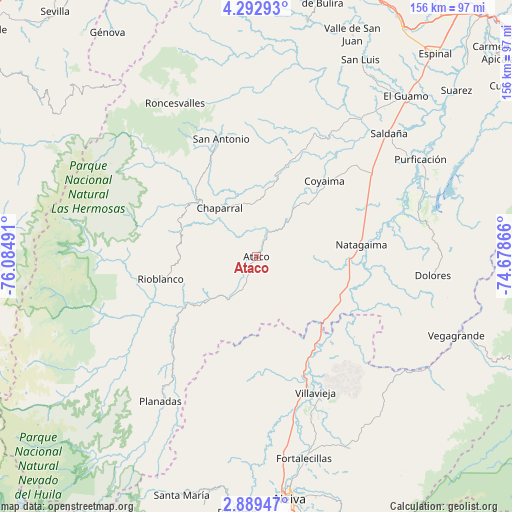
Ataco GPS coordinates[2]
3° 35' 29.292" North, 75° 22' 54.408" West
| Map corner | latitude | longitude |
|---|---|---|
| Upper-left | 4.29293°, | -76.08491° |
| Center: | 3.59147°, | -75.38178° |
| Lower-right: | 2.88947°, | -74.67866° |
| Map W x H: | 156.1×156.1 km | = 97×97mi |
| max Lat: | 13.38166° ⇑80.8% North |
| Ataco: | 3.59147° |
| min Lat: | ⇓19.2% South -4.21528° |
| min Long | Ataco | max Long |
| -81.70636° | -75.38178° | -67.06996° |
| W 36.4%⇐ | ⇒63.6% E |
Elevation
Elevation of Ataco is 453 m = 1486 ft, and this is 696.3 m = 2284 ft below average elevation for this country.
| Max E: |
3342 m = 10965 ft | 64.7% |
| Avg. | 1149.3 m = 3771 ft | |
| Ataco | 453 m = 1486 ft | |
Min E: |
1 m = 3 ft | 35.3% |
See also: Colombia elevation on elevation.city.
Geographical zone
Ataco is located in North Torrid zone (between Equator and Tropic of Cancer). Distance of Equator is 399.3 km =248.1 mi to South.| Distance of | km | miles | from Ataco |
|---|---|---|---|
| North Pole | 9607.7 | 5969.9 | to North |
| Arctic Circle | 7001.8 | 4350.7 | to North |
| Tropic Cancer | 2206.6 | 1371.1 | to North |
| Equator | 399.3 | 248.1 | to South |


Nearby cities:
15 places around Ataco: (largest is in red/bold)
• Aipe
44.1 km =27.4 mi,  158°
158°
• Chaparral
18.5 km =11.5 mi,  322°
322°
• Coyaima
31.1 km =19.3 mi,  41°
41°
• Dolores
54.1 km =33.6 mi,  96°
96°
• Natagaima
32.1 km =19.9 mi,  84°
84°
• Ortega
42.2 km =26.2 mi,  24°
24°
• Planadas
52.7 km =32.7 mi,  213°
213°
• Playarrica
51.9 km =32.2 mi,  356°
356°
• Prado
53.2 km =33.1 mi,  70°
70°
• Rioblanco
30 km =18.6 mi,  256°
256°
• Roncesvalles
52.8 km =32.8 mi,  332°
332°
• San Antonio
37.5 km =23.3 mi,  343°
343°
• Santa Isabel
52 km =32.3 mi,  121°
121°
• Santiago Pérez
32.8 km =20.4 mi,  229°
229°
• Villavieja
45 km =28 mi, 156°
Sources, notices
• [Note1] Compared only with cities in Colombia existing in our database
• [Src1] Map data: © OpenStreetMap contributors (CC-BY-SA)
• [Src2] Other city data from geonames.org with taken over terms of usage.
• [Src3] Geographical zone / Annual Mean Temperature by Robert A. Rohde @ Wikipedia
