Villavieja geodata
Villavieja (Huila) is a seat of a second-order administrative division; located in Colombia in America/Bogota (GMT-5) time zone. With population of 2,730 people, there are 709 cities with bigger population in this country. Compared to other cities in Colombia, 83.1% of cities are located further ↑North; 59.5% of cities are located further →East and 66.8% of cities have higher elevation than Villavieja. Note1


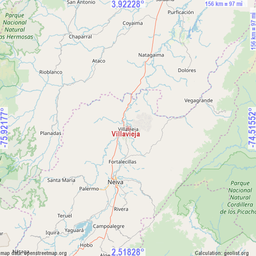
Villavieja GPS coordinates[2]
3° 13' 13.872" North, 75° 13' 7.104" West
| Map corner | latitude | longitude |
|---|---|---|
| Upper-left | 3.92228°, | -75.92177° |
| Center: | 3.22052°, | -75.21864° |
| Lower-right: | 2.51828°, | -74.51552° |
| Map W x H: | 156.1×156.1 km | = 97×97mi |
| max Lat: | 13.38166° ⇑83.1% North |
| Villavieja: | 3.22052° |
| min Lat: | ⇓16.9% South -4.21528° |
| min Long | Villavieja | max Long |
| -81.70636° | -75.21864° | -67.06996° |
| W 40.5%⇐ | ⇒59.5% E |
Elevation
Elevation of Villavieja is 384 m = 1260 ft, and this is 765.3 m = 2511 ft below average elevation for this country.
| Max E: |
3342 m = 10965 ft | 66.8% |
| Avg. | 1149.3 m = 3771 ft | |
| Villavieja | 384 m = 1260 ft | |
Min E: |
1 m = 3 ft | 33.2% |
See also: Colombia elevation on elevation.city.
Geographical zone
Villavieja is located in North Torrid zone (between Equator and Tropic of Cancer). Distance of Equator is 358.1 km =222.5 mi to South.| Distance of | km | miles | from Villavieja |
|---|---|---|---|
| North Pole | 9649 | 5995.6 | to North |
| Arctic Circle | 7043.1 | 4376.4 | to North |
| Tropic Cancer | 2247.8 | 1396.7 | to North |
| Equator | 358.1 | 222.5 | to South |


Nearby cities:
15 places around Villavieja: (largest is in red/bold)
• Aipe
2 km =1.2 mi,  275°
275°
• Alpujarra
36.9 km =22.9 mi,  58°
58°
• Ataco
45 km =28 mi,  336°
336°
• Baraya
19.8 km =12.3 mi,  112°
112°
• Colombia
49.4 km =30.7 mi,  69°
69°
• Dolores
50.3 km =31.3 mi,  45°
45°
• Natagaima
46.6 km =29 mi,  17°
17°
• Neiva
33.4 km =20.8 mi,  192°
192°
• Palermo
43.9 km =27.3 mi,  213°
213°
• Planadas
47.4 km =29.5 mi,  266°
266°
• Rivera
49.5 km =30.8 mi,  184°
184°
• Santa Isabel
30.1 km =18.7 mi, 61°
• Santa María
51.4 km =31.9 mi,  232°
232°
• Santiago Pérez
47.2 km =29.3 mi,  294°
294°
• Tello
19.3 km =12 mi,  152°
152°
Sources, notices
• [Note1] Compared only with cities in Colombia existing in our database
• [Src1] Map data: © OpenStreetMap contributors (CC-BY-SA)
• [Src2] Other city data from geonames.org with taken over terms of usage.
• [Src3] Geographical zone / Annual Mean Temperature by Robert A. Rohde @ Wikipedia
