Natagaima geodata
Natagaima (Tolima) is a seat of a second-order administrative division; located in Colombia in America/Bogota (GMT-5) time zone. With population of 11,217 people, there are 273 cities with bigger population in this country. Compared to other cities in Colombia, 80.8% of cities are located further ↑North; 56% of cities are located further →East and 68.3% of cities have higher elevation than Natagaima. Note1


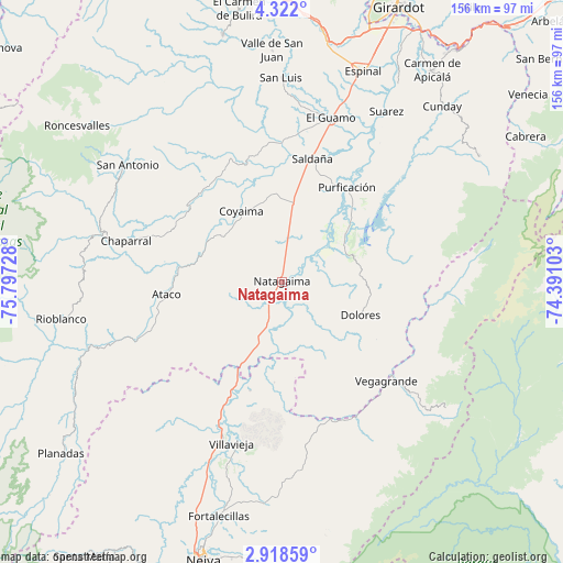
Natagaima GPS coordinates[2]
3° 37' 14.052" North, 75° 5' 38.94" West
| Map corner | latitude | longitude |
|---|---|---|
| Upper-left | 4.322°, | -75.79728° |
| Center: | 3.62057°, | -75.09415° |
| Lower-right: | 2.91859°, | -74.39103° |
| Map W x H: | 156×156 km | = 96.9×96.9mi |
| max Lat: | 13.38166° ⇑80.8% North |
| Natagaima: | 3.62057° |
| min Lat: | ⇓19.2% South -4.21528° |
| min Long | Natagaima | max Long |
| -81.70636° | -75.09415° | -67.06996° |
| W 44%⇐ | ⇒56% E |
Elevation
Elevation of Natagaima is 326 m = 1070 ft, and this is 823.3 m = 2701 ft below average elevation for this country.
| Max E: |
3342 m = 10965 ft | 68.3% |
| Avg. | 1149.3 m = 3771 ft | |
| Natagaima | 326 m = 1070 ft | |
Min E: |
1 m = 3 ft | 31.7% |
See also: Colombia elevation on elevation.city.
Geographical zone
Natagaima is located in North Torrid zone (between Equator and Tropic of Cancer). Distance of Equator is 402.6 km =250.2 mi to South.| Distance of | km | miles | from Natagaima |
|---|---|---|---|
| North Pole | 9604.5 | 5968 | to North |
| Arctic Circle | 6998.6 | 4348.7 | to North |
| Tropic Cancer | 2203.3 | 1369.1 | to North |
| Equator | 402.6 | 250.2 | to South |


Nearby cities:
15 places around Natagaima: (largest is in red/bold)
• Aipe
47 km =29.2 mi,  199°
199°
• Alpujarra
31.1 km =19.3 mi,  144°
144°
• Ataco
32.1 km =19.9 mi,  264°
264°
• Chaparral
44.6 km =27.7 mi,  284°
284°
• Colombia
42.4 km =26.3 mi,  129°
129°
• Coyaima
22.8 km =14.2 mi,  330°
330°
• Dolores
23.6 km =14.7 mi,  112°
112°
• Guamo
47.6 km =29.6 mi,  16°
16°
• Ortega
37.8 km =23.5 mi,  338°
338°
• Prado
23.3 km =14.5 mi,  51°
51°
• Purificación
32.1 km =19.9 mi,  34°
34°
• Saldaña
35.4 km =22 mi,  14°
14°
• Santa Isabel
32.7 km =20.3 mi,  157°
157°
• Tres Esquinas
50.6 km =31.4 mi,  57°
57°
• Villavieja
46.6 km =29 mi, 197°
Sources, notices
• [Note1] Compared only with cities in Colombia existing in our database
• [Src1] Map data: © OpenStreetMap contributors (CC-BY-SA)
• [Src2] Other city data from geonames.org with taken over terms of usage.
• [Src3] Geographical zone / Annual Mean Temperature by Robert A. Rohde @ Wikipedia
