Roncesvalles geodata
Roncesvalles (Tolima) is a seat of a second-order administrative division; located in Colombia in America/Bogota (GMT-5) time zone. With population of 3,918 people, there are 593 cities with bigger population in this country. Compared to other cities in Colombia, 77.9% of cities are located further ↑North; 69% of cities are located further →East and 92.9% of cities have lower elevation than Roncesvalles. Note1


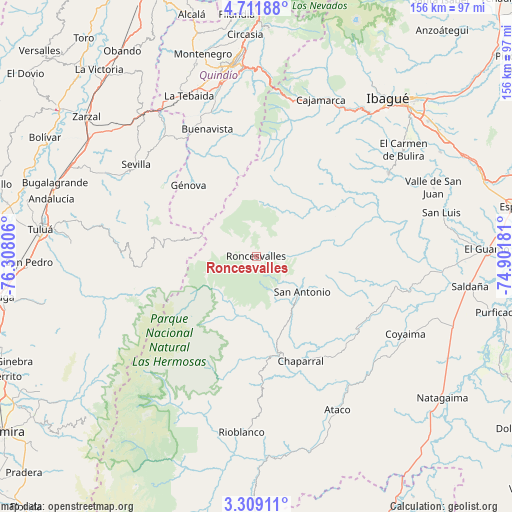
Roncesvalles GPS coordinates[2]
4° 0' 38.88" North, 75° 36' 17.748" West
| Map corner | latitude | longitude |
|---|---|---|
| Upper-left | 4.71188°, | -76.30806° |
| Center: | 4.0108°, | -75.60493° |
| Lower-right: | 3.30911°, | -74.90181° |
| Map W x H: | 156×156 km | = 96.9×96.9mi |
| max Lat: | 13.38166° ⇑77.9% North |
| Roncesvalles: | 4.0108° |
| min Lat: | ⇓22.1% South -4.21528° |
| min Long | Roncesvalles | max Long |
| -81.70636° | -75.60493° | -67.06996° |
| W 31%⇐ | ⇒69% E |
Elevation
Elevation of Roncesvalles is 2597 m = 8520 ft, and this is 1447.7 m = 4750 ft above average elevation for this country.
| Max E: |
3342 m = 10965 ft | 7.1% |
| Roncesvalles | 2597 m 8520 ft | |
| Avg. | 1149.3 m = 3771 ft | |
Min E: |
1 m = 3 ft | 92.9% |
See also: Colombia elevation on elevation.city.
Geographical zone
Roncesvalles is located in North Torrid zone (between Equator and Tropic of Cancer). Distance of Equator is 446 km =277.1 mi to South.| Distance of | km | miles | from Roncesvalles |
|---|---|---|---|
| North Pole | 9561.1 | 5941 | to North |
| Arctic Circle | 6955.2 | 4321.8 | to North |
| Tropic Cancer | 2160 | 1342.2 | to North |
| Equator | 446 | 277.1 | to South |


Nearby cities:
15 places around Roncesvalles: (largest is in red/bold)
• Anaime
46.4 km =28.8 mi,  22°
22°
• Buenavista
41.5 km =25.8 mi,  339°
339°
• Caicedonia
43.4 km =27 mi,  325°
325°
• Chaparral
34.7 km =21.6 mi,  157°
157°
• Coyaima
51.2 km =31.8 mi,  117°
117°
• Córdoba
43.3 km =26.9 mi,  347°
347°
• Génova
29.9 km =18.6 mi,  317°
317°
• Génova
38.4 km =23.9 mi, 332°
• Laureles
41.8 km =26 mi,  48°
48°
• Ortega
43.3 km =26.9 mi,  101°
101°
• Pijao
37.5 km =23.3 mi, 342°
• Playarrica
22.2 km =13.8 mi,  76°
76°
• Rovira
47.8 km =29.7 mi,  57°
57°
• San Antonio
17.5 km =10.9 mi,  127°
127°
• Sevilla
45.8 km =28.5 mi,  307°
307°
Sources, notices
• [Note1] Compared only with cities in Colombia existing in our database
• [Src1] Map data: © OpenStreetMap contributors (CC-BY-SA)
• [Src2] Other city data from geonames.org with taken over terms of usage.
• [Src3] Geographical zone / Annual Mean Temperature by Robert A. Rohde @ Wikipedia
