Cáceres geodata
Cáceres (Antioquia) is a seat of a second-order administrative division; located in Colombia in America/Bogota (GMT-5) time zone. With population of 4,987 people, there are 509 cities with bigger population in this country. Compared to other cities in Colombia, 78.4% of cities are located further ↓South; 63% of cities are located further →East and 81.6% of cities have higher elevation than Cáceres. Note1


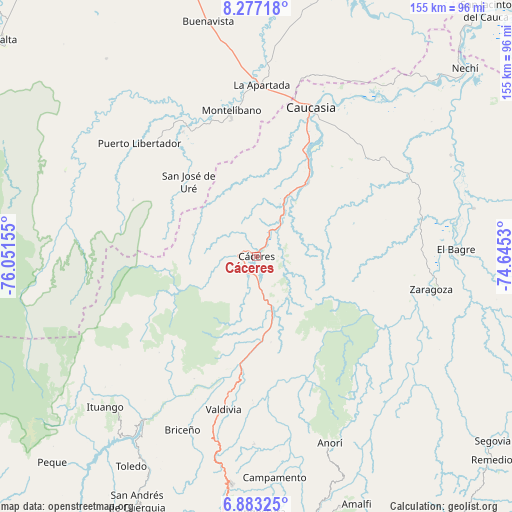
Cáceres GPS coordinates[2]
7° 34' 50.808" North, 75° 20' 54.312" West
| Map corner | latitude | longitude |
|---|---|---|
| Upper-left | 8.27718°, | -76.05155° |
| Center: | 7.58078°, | -75.34842° |
| Lower-right: | 6.88325°, | -74.6453° |
| Map W x H: | 155×155 km | = 96.3×96.3mi |
| max Lat: | 13.38166° ⇑21.6% North |
| Cáceres: | 7.58078° |
| min Lat: | ⇓78.4% South -4.21528° |
| min Long | Cáceres | max Long |
| -81.70636° | -75.34842° | -67.06996° |
| W 37%⇐ | ⇒63% E |
Elevation
Elevation of Cáceres is 95 m = 312 ft, and this is 1054.3 m = 3459 ft below average elevation for this country.
| Max E: |
3342 m = 10965 ft | 81.6% |
| Avg. | 1149.3 m = 3771 ft | |
| Cáceres | 95 m = 312 ft | |
Min E: |
1 m = 3 ft | 18.4% |
See also: Colombia elevation on elevation.city.
Geographical zone
Cáceres is located in North Torrid zone (between Equator and Tropic of Cancer). Distance of Equator is 842.9 km =523.8 mi to South.| Distance of | km | miles | from Cáceres |
|---|---|---|---|
| North Pole | 9164.2 | 5694.4 | to North |
| Arctic Circle | 6558.3 | 4075.1 | to North |
| Tropic Cancer | 1763 | 1095.5 | to North |
| Equator | 842.9 | 523.8 | to South |


Nearby cities:
15 places around Cáceres: (largest is in red/bold)
• Anorí
60.7 km =37.7 mi,  158°
158°
• Briceño
56.8 km =35.3 mi,  203°
203°
• Campamento
67.1 km =41.7 mi,  175°
175°
• Caucasia
48.2 km =30 mi,  20°
20°
• Cruces de Anorí
54 km =33.6 mi,  144°
144°
• El Bagre
59.4 km =36.9 mi,  87°
87°
• Ituango
64.6 km =40.1 mi,  225°
225°
• La Apartada
52.1 km =32.4 mi,  1°
1°
• Montelíbano
45 km =28 mi,  349°
349°
• Puerto Libertador
49.3 km =30.6 mi,  314°
314°
• San José de Uré
30.6 km =19 mi,  318°
318°
• Tarazá
5.8 km =3.6 mi,  273°
273°
• Valdivia
32.3 km =20.1 mi,  188°
188°
• Valdivia
47.4 km =29.5 mi, 192°
• Zaragoza
53.8 km =33.4 mi,  100°
100°
Sources, notices
• [Note1] Compared only with cities in Colombia existing in our database
• [Src1] Map data: © OpenStreetMap contributors (CC-BY-SA)
• [Src2] Other city data from geonames.org with taken over terms of usage.
• [Src3] Geographical zone / Annual Mean Temperature by Robert A. Rohde @ Wikipedia
