Paquera geodata
Paquera (Puntarenas) is a populated place; located in Costa Rica in America/Costa_Rica (GMT-6) time zone. With population of 1,510 people, there are 113 cities with bigger population in this country. Compared to other cities in Costa Rica, 82.8% of cities are located further ↑North; 85.8% of cities are located further →East and 91% of cities have higher elevation than Paquera. Note1


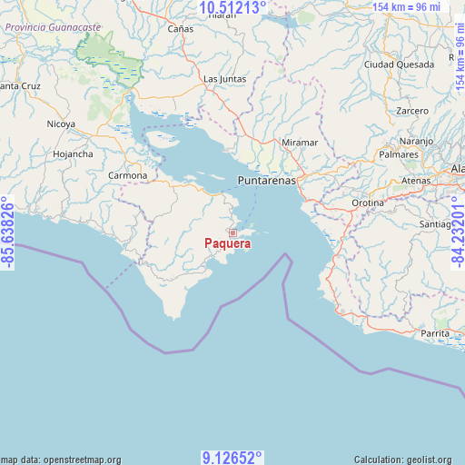
Paquera GPS coordinates[2]
9° 49' 12.18" North, 84° 56' 6.468" West
| Map corner | latitude | longitude |
|---|---|---|
| Upper-left | 10.51213°, | -85.63826° |
| Center: | 9.82005°, | -84.93513° |
| Lower-right: | 9.12652°, | -84.23201° |
| Map W x H: | 154.1×154.1 km | = 95.8×95.8mi |
| max Lat: | 11.07377° ⇑82.8% North |
| Paquera: | 9.82005° |
| min Lat: | ⇓17.2% South 8.53305° |
| min Long | Paquera | max Long |
| -85.64748° | -84.93513° | -82.62185° |
| W 14.2%⇐ | ⇒85.8% E |
Elevation
Elevation of Paquera is 19 m = 62 ft, and this is 716 m = 2349 ft below average elevation for this country.
| Max E: |
1844 m = 6050 ft | 91% |
| Avg. | 735 m = 2411 ft | |
| Paquera | 19 m = 62 ft | |
Min E: |
7 m = 23 ft | 9% |
See also: Costa Rica elevation on elevation.city.
Geographical zone
Paquera is located in North Torrid zone (between Equator and Tropic of Cancer). Distance of Equator is 1091.9 km =678.5 mi to South.| Distance of | km | miles | from Paquera |
|---|---|---|---|
| North Pole | 8915.2 | 5539.6 | to North |
| Arctic Circle | 6309.3 | 3920.4 | to North |
| Tropic Cancer | 1514 | 940.8 | to North |
| Equator | 1091.9 | 678.5 | to South |


Nearby cities:
15 places around Paquera: (largest is in red/bold)
• Barrio Jesús
58.8 km =36.5 mi,  73°
73°
• Bejuco
43.3 km =26.9 mi,  274°
274°
• Chacarita
25 km =15.5 mi,  43°
43°
• Desamparados
49.1 km =30.5 mi, 73°
• Esparza
35.4 km =22 mi,  56°
56°
• Jacó
40.5 km =25.2 mi,  124°
124°
• Juntas
51.3 km =31.9 mi,  357°
357°
• Macacona
38.2 km =23.7 mi, 57°
• Miramar
37.7 km =23.4 mi, 36°
• Nandayure
37.5 km =23.3 mi,  309°
309°
• Orotina
46.2 km =28.7 mi,  77°
77°
• Puntarenas
20.3 km =12.6 mi,  31°
31°
• San Rafael
57.4 km =35.7 mi, 61°
• Santiago
58.3 km =36.2 mi, 67°
• Zapotal
44.7 km =27.8 mi,  296°
296°
Sources, notices
• [Note1] Compared only with cities in Costa Rica existing in our database
• [Src1] Map data: © OpenStreetMap contributors (CC-BY-SA)
• [Src2] Other city data from geonames.org with taken over terms of usage.
• [Src3] Geographical zone / Annual Mean Temperature by Robert A. Rohde @ Wikipedia
