Juntas geodata
Juntas (Guanacaste) is a populated place; located in Costa Rica in America/Costa_Rica (GMT-6) time zone. With population of 4,737 people, there are 75 cities with bigger population in this country. Compared to other cities in Costa Rica, 85.8% of cities are located further ↓South; 86.6% of cities are located further →East and 74.6% of cities have higher elevation than Juntas. Note1


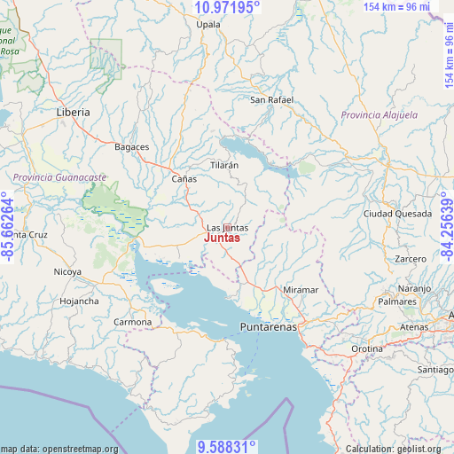
Juntas GPS coordinates[2]
10° 16' 51.204" North, 84° 57' 34.236" West
| Map corner | latitude | longitude |
|---|---|---|
| Upper-left | 10.97195°, | -85.66264° |
| Center: | 10.28089°, | -84.95951° |
| Lower-right: | 9.58831°, | -84.25639° |
| Map W x H: | 153.8×153.8 km | = 95.6×95.6mi |
| max Lat: | 11.07377° ⇑14.2% North |
| Juntas: | 10.28089° |
| min Lat: | ⇓85.8% South 8.53305° |
| min Long | Juntas | max Long |
| -85.64748° | -84.95951° | -82.62185° |
| W 13.4%⇐ | ⇒86.6% E |
Elevation
Elevation of Juntas is 154 m = 505 ft, and this is 581 m = 1906 ft below average elevation for this country.
| Max E: |
1844 m = 6050 ft | 74.6% |
| Avg. | 735 m = 2411 ft | |
| Juntas | 154 m = 505 ft | |
Min E: |
7 m = 23 ft | 25.4% |
See also: Costa Rica elevation on elevation.city.
Geographical zone
Juntas is located in North Torrid zone (between Equator and Tropic of Cancer). Distance of Equator is 1143.1 km =710.3 mi to South.| Distance of | km | miles | from Juntas |
|---|---|---|---|
| North Pole | 8863.9 | 5507.8 | to North |
| Arctic Circle | 6258 | 3888.5 | to North |
| Tropic Cancer | 1462.8 | 908.9 | to North |
| Equator | 1143.1 | 710.3 | to South |


Nearby cities:
15 places around Juntas: (largest is in red/bold)
• Bagaces
42.3 km =26.3 mi,  310°
310°
• Bijagua
51.4 km =31.9 mi,  348°
348°
• Cañas
22.6 km =14 mi,  317°
317°
• Chacarita
38.5 km =23.9 mi,  149°
149°
• Esparza
45.3 km =28.1 mi,  134°
134°
• Fortuna
51 km =31.7 mi,  328°
328°
• La Fortuna
40.3 km =25 mi,  58°
58°
• Macacona
46.7 km =29 mi, 131°
• Miramar
32.7 km =20.3 mi, 129°
• Nandayure
38.1 km =23.7 mi,  223°
223°
• Paquera
51.3 km =31.9 mi,  177°
177°
• Pocosol
38.7 km =24 mi,  75°
75°
• Puntarenas
36.4 km =22.6 mi,  158°
158°
• Tilarán
20.7 km =12.9 mi,  357°
357°
• Zapotal
48.6 km =30.2 mi,  230°
230°
Sources, notices
• [Note1] Compared only with cities in Costa Rica existing in our database
• [Src1] Map data: © OpenStreetMap contributors (CC-BY-SA)
• [Src2] Other city data from geonames.org with taken over terms of usage.
• [Src3] Geographical zone / Annual Mean Temperature by Robert A. Rohde @ Wikipedia
