Puntarenas geodata
Puntarenas is a seat of a first-order administrative division; located in Costa Rica in America/Costa_Rica (GMT-6) time zone. With population of 35,650 people, there are 6 cities with bigger population in this country. Compared to other cities in Costa Rica, 52.2% of cities are located further ↓South; 85.1% of cities are located further →East and 97% of cities have higher elevation than Puntarenas. Note1


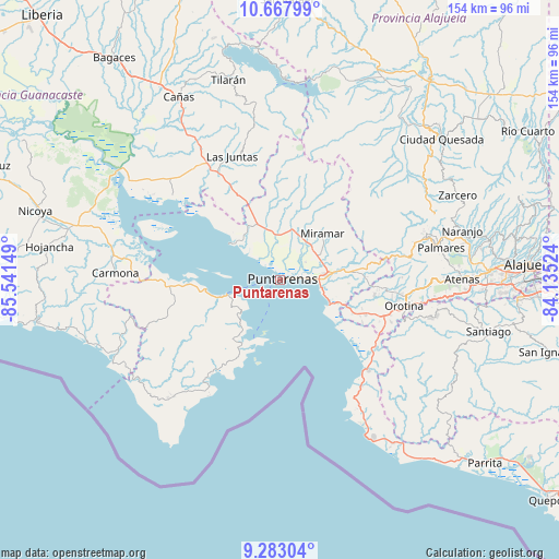
Puntarenas GPS coordinates[2]
9° 58' 34.5" North, 84° 50' 18.096" West
| Map corner | latitude | longitude |
|---|---|---|
| Upper-left | 10.66799°, | -85.54149° |
| Center: | 9.97625°, | -84.83836° |
| Lower-right: | 9.28304°, | -84.13524° |
| Map W x H: | 154×154 km | = 95.7×95.7mi |
| max Lat: | 11.07377° ⇑47.8% North |
| Puntarenas: | 9.97625° |
| min Lat: | ⇓52.2% South 8.53305° |
| min Long | Puntarenas | max Long |
| -85.64748° | -84.83836° | -82.62185° |
| W 14.9%⇐ | ⇒85.1% E |
Elevation
Elevation of Puntarenas is 9 m = 30 ft, and this is 726 m = 2382 ft below average elevation for this country.
| Max E: |
1844 m = 6050 ft | 97% |
| Avg. | 735 m = 2411 ft | |
| Puntarenas | 9 m = 30 ft | |
Min E: |
7 m = 23 ft | 3% |
See also: Costa Rica elevation on elevation.city.
Geographical zone
Puntarenas is located in North Torrid zone (between Equator and Tropic of Cancer). Distance of Equator is 1109.3 km =689.3 mi to South.| Distance of | km | miles | from Puntarenas |
|---|---|---|---|
| North Pole | 8897.8 | 5528.8 | to North |
| Arctic Circle | 6291.9 | 3909.6 | to North |
| Tropic Cancer | 1496.7 | 930 | to North |
| Equator | 1109.3 | 689.3 | to South |


Nearby cities:
15 places around Puntarenas: (largest is in red/bold)
• Barrio Jesús
45.6 km =28.3 mi,  90°
90°
• Chacarita
6.6 km =4.1 mi,  82°
82°
• Desamparados
36.5 km =22.7 mi,  95°
95°
• Esparza
19.1 km =11.9 mi, 83°
• Esquipulas
46.3 km =28.8 mi, 78°
• Jacó
46.2 km =28.7 mi,  150°
150°
• Juntas
36.4 km =22.6 mi,  338°
338°
• Macacona
21.9 km =13.6 mi, 82°
• Miramar
17.6 km =10.9 mi,  42°
42°
• Nandayure
40.1 km =24.9 mi,  279°
279°
• Orotina
35.2 km =21.9 mi, 101°
• Paquera
20.3 km =12.6 mi,  211°
211°
• San Rafael
41.2 km =25.6 mi, 76°
• San Ramón
42.2 km =26.2 mi,  72°
72°
• Santiago
43.5 km =27 mi, 83°
Sources, notices
• [Note1] Compared only with cities in Costa Rica existing in our database
• [Src1] Map data: © OpenStreetMap contributors (CC-BY-SA)
• [Src2] Other city data from geonames.org with taken over terms of usage.
• [Src3] Geographical zone / Annual Mean Temperature by Robert A. Rohde @ Wikipedia
