Carrillos geodata
Carrillos (Alajuela) is a populated place; located in Costa Rica in America/Costa_Rica (GMT-6) time zone. With population of 4,258 people, there are 81 cities with bigger population in this country. Compared to other cities in Costa Rica, 65.7% of cities are located further ↓South; 63.4% of cities are located further →East and 50.7% of cities have higher elevation than Carrillos. Note1


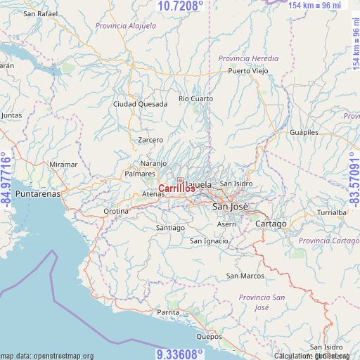
Carrillos GPS coordinates[2]
10° 1' 45.048" North, 84° 16' 26.508" West
| Map corner | latitude | longitude |
|---|---|---|
| Upper-left | 10.7208°, | -84.97716° |
| Center: | 10.02918°, | -84.27403° |
| Lower-right: | 9.33608°, | -83.57091° |
| Map W x H: | 154×154 km | = 95.7×95.7mi |
| max Lat: | 11.07377° ⇑34.3% North |
| Carrillos: | 10.02918° |
| min Lat: | ⇓65.7% South 8.53305° |
| min Long | Carrillos | max Long |
| -85.64748° | -84.27403° | -82.62185° |
| W 36.6%⇐ | ⇒63.4% E |
Elevation
Elevation of Carrillos is 834 m = 2736 ft, and this is 99 m = 325 ft above average elevation for this country.
| Max E: |
1844 m = 6050 ft | 50.7% |
| Carrillos | 834 m 2736 ft | |
| Avg. | 735 m = 2411 ft | |
Min E: |
7 m = 23 ft | 49.3% |
See also: Costa Rica elevation on elevation.city.
Geographical zone
Carrillos is located in North Torrid zone (between Equator and Tropic of Cancer). Distance of Equator is 1115.1 km =692.9 mi to South.| Distance of | km | miles | from Carrillos |
|---|---|---|---|
| North Pole | 8891.9 | 5525.2 | to North |
| Arctic Circle | 6286 | 3905.9 | to North |
| Tropic Cancer | 1490.8 | 926.3 | to North |
| Equator | 1115.1 | 692.9 | to South |


Nearby cities:
15 places around Carrillos: (largest is in red/bold)
• Alajuela
7 km =4.3 mi,  101°
101°
• Atenas
13 km =8.1 mi,  242°
242°
• Colón
13.2 km =8.2 mi,  164°
164°
• Esquipulas
16.6 km =10.3 mi,  280°
280°
• La Asunción
12.4 km =7.7 mi,  116°
116°
• Llorente
13.5 km =8.4 mi, 104°
• Mercedes
15.5 km =9.6 mi, 99°
• Naranjo
13.8 km =8.6 mi,  304°
304°
• Sabanilla
8.1 km =5 mi,  52°
52°
• San Antonio
11.2 km =7 mi, 117°
• San Francisco
16.3 km =10.1 mi, 104°
• San Juan
9.4 km =5.8 mi,  330°
330°
• Santa Ana
14.7 km =9.1 mi,  136°
136°
• Santo Domingo
13.6 km =8.5 mi,  73°
73°
• Sarchí
10.5 km =6.5 mi,  309°
309°
Sources, notices
• [Note1] Compared only with cities in Costa Rica existing in our database
• [Src1] Map data: © OpenStreetMap contributors (CC-BY-SA)
• [Src2] Other city data from geonames.org with taken over terms of usage.
• [Src3] Geographical zone / Annual Mean Temperature by Robert A. Rohde @ Wikipedia
