Encrucijada geodata
Encrucijada (Villa Clara) is a seat of a second-order administrative division; located in Cuba in America/Havana (GMT-4) time zone. With population of 26,155 people, there are 85 cities with bigger population in this country. Compared to other cities in Cuba, 64.1% of cities are located further ↓South; 50.8% of cities are located further ←West and 53.6% of cities have lower elevation than Encrucijada. Note1


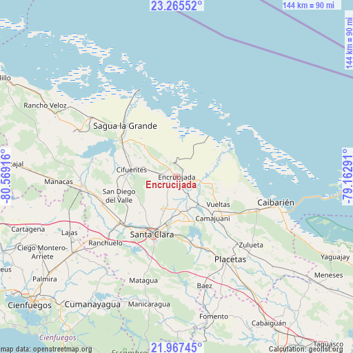
Encrucijada GPS coordinates[2]
22° 37' 4.872" North, 79° 51' 57.708" West
| Map corner | latitude | longitude |
|---|---|---|
| Upper-left | 23.26552°, | -80.56916° |
| Center: | 22.61802°, | -79.86603° |
| Lower-right: | 21.96745°, | -79.16291° |
| Map W x H: | 144.3×144.3 km | = 89.7×89.7mi |
| max Lat: | 23.15917° ⇑35.9% North |
| Encrucijada: | 22.61802° |
| min Lat: | ⇓64.1% South 19.90553° |
| min Long | Encrucijada | max Long |
| -84.28599° | -79.86603° | -74.15181° |
| W 50.8%⇐ | ⇒49.2% E |
Elevation
Elevation of Encrucijada is 56 m = 184 ft, and this is 12.6 m = 41 ft below average elevation for this country.
| Max E: |
761 m = 2497 ft | 46.4% |
| Avg. | 68.6 m = 225 ft | |
| Encrucijada | 56 m = 184 ft | |
Min E: |
3 m = 10 ft | 53.6% |
See also: Cuba elevation on elevation.city.
Geographical zone
Encrucijada is located in North Torrid zone (between Equator and Tropic of Cancer). Distance of this Northern Tropic circle is 91 km =56.5 mi to North.| Distance of | km | miles | from Encrucijada |
|---|---|---|---|
| North Pole | 7492.2 | 4655.4 | to North |
| Arctic Circle | 4886.3 | 3036.2 | to North |
| Tropic Cancer | 91 | 56.5 | to North |
| Equator | 2514.9 | 1562.7 | to South |


Nearby cities:
15 places around Encrucijada: (largest is in red/bold)
• Caibarién
42.5 km =26.4 mi,  104°
104°
• Calabazar de Sagua
4.2 km =2.6 mi,  315°
315°
• Camajuaní
19.1 km =11.9 mi,  141°
141°
• Camajuaní
22.5 km =14 mi, 139°
• Cifuentes
19.1 km =11.9 mi,  280°
280°
• Esperanza
30.4 km =18.9 mi,  231°
231°
• Isabela de Sagua
38.7 km =24 mi,  337°
337°
• Lajas
49.3 km =30.6 mi,  242°
242°
• Placetas
40.4 km =25.1 mi,  147°
147°
• Quemado de Güines
43.9 km =27.3 mi,  295°
295°
• Ranchuelo
40 km =24.9 mi, 226°
• Remedios
35.6 km =22.1 mi,  112°
112°
• Sagua la Grande
30 km =18.6 mi,  314°
314°
• Santa Clara
25.6 km =15.9 mi,  203°
203°
• Santo Domingo
38.8 km =24.1 mi,  264°
264°
Sources, notices
• [Note1] Compared only with cities in Cuba existing in our database
• [Src1] Map data: © OpenStreetMap contributors (CC-BY-SA)
• [Src2] Other city data from geonames.org with taken over terms of usage.
• [Src3] Geographical zone / Annual Mean Temperature by Robert A. Rohde @ Wikipedia
