Santa Clara geodata
Santa Clara (Villa Clara) is a seat of a first-order administrative division; located in Cuba in America/Havana (GMT-4) time zone. With population of 250,512 people, there are 5 cities with bigger population in this country. Compared to other cities in Cuba, 55.8% of cities are located further ↓South; 50.3% of cities are located further →East and 88.4% of cities have lower elevation than Santa Clara. Note1


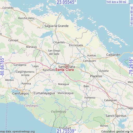
Santa Clara GPS coordinates[2]
22° 24' 24.984" North, 79° 57' 52.992" West
| Map corner | latitude | longitude |
|---|---|---|
| Upper-left | 23.05545°, | -80.66785° |
| Center: | 22.40694°, | -79.96472° |
| Lower-right: | 21.75539°, | -79.2616° |
| Map W x H: | 144.6×144.6 km | = 89.9×89.9mi |
| max Lat: | 23.15917° ⇑44.2% North |
| Santa Clara: | 22.40694° |
| min Lat: | ⇓55.8% South 19.90553° |
| min Long | Santa Clara | max Long |
| -84.28599° | -79.96472° | -74.15181° |
| W 49.7%⇐ | ⇒50.3% E |
Elevation
Elevation of Santa Clara is 126 m = 413 ft, and this is 57.4 m = 188 ft above average elevation for this country.
| Max E: |
761 m = 2497 ft | 11.6% |
| Santa Clara | 126 m 413 ft | |
| Avg. | 68.6 m = 225 ft | |
Min E: |
3 m = 10 ft | 88.4% |
See also: Santa Clara elevation on elevation.city.
Geographical zone
Santa Clara is located in North Torrid zone (between Equator and Tropic of Cancer). Distance of this Northern Tropic circle is 114.5 km =71.1 mi to North.| Distance of | km | miles | from Santa Clara |
|---|---|---|---|
| North Pole | 7515.6 | 4670 | to North |
| Arctic Circle | 4909.8 | 3050.8 | to North |
| Tropic Cancer | 114.5 | 71.1 | to North |
| Equator | 2491.4 | 1548.1 | to South |


Nearby cities:
15 places around Santa Clara: (largest is in red/bold)
• Calabazar de Sagua
27.4 km =17 mi,  15°
15°
• Camajuaní
23.6 km =14.7 mi,  68°
68°
• Camajuaní
25.6 km =15.9 mi,  75°
75°
• Cifuentes
28.3 km =17.6 mi,  342°
342°
• Cruces
32.2 km =20 mi,  257°
257°
• Cumanayagua
37.5 km =23.3 mi,  220°
220°
• Encrucijada
25.6 km =15.9 mi, 23°
• Esperanza
14.3 km =8.9 mi,  288°
288°
• Fomento
41.9 km =26 mi,  143°
143°
• Lajas
33.8 km =21 mi,  271°
271°
• Manicaragua
28.6 km =17.8 mi,  182°
182°
• Placetas
33.6 km =20.9 mi,  108°
108°
• Ranchuelo
19.5 km =12.1 mi, 258°
• Remedios
44.2 km =27.5 mi, 77°
• Santo Domingo
34.9 km =21.7 mi,  305°
305°
Sources, notices
• [Note1] Compared only with cities in Cuba existing in our database
• [Src1] Map data: © OpenStreetMap contributors (CC-BY-SA)
• [Src2] Other city data from geonames.org with taken over terms of usage.
• [Src3] Geographical zone / Annual Mean Temperature by Robert A. Rohde @ Wikipedia
