Calabazar de Sagua geodata
Calabazar de Sagua (Villa Clara) is a populated place; located in Cuba in America/Havana (GMT-4) time zone. With population of 10,455 people, there are 139 cities with bigger population in this country. Compared to other cities in Cuba, 65.2% of cities are located further ↓South; 50.3% of cities are located further ←West and 56.9% of cities have lower elevation than Calabazar de Sagua. Note1


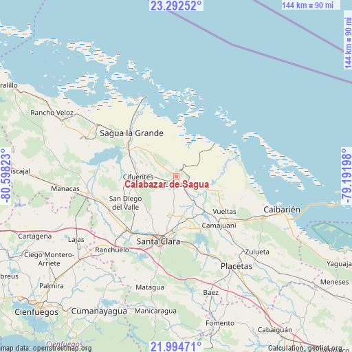
Calabazar de Sagua GPS coordinates[2]
22° 38' 42.54" North, 79° 53' 42.36" West
| Map corner | latitude | longitude |
|---|---|---|
| Upper-left | 23.29252°, | -80.59823° |
| Center: | 22.64515°, | -79.8951° |
| Lower-right: | 21.99471°, | -79.19198° |
| Map W x H: | 144.3×144.3 km | = 89.7×89.7mi |
| max Lat: | 23.15917° ⇑34.8% North |
| Calabazar de Sagua: | 22.64515° |
| min Lat: | ⇓65.2% South 19.90553° |
| min Long | Calabazar de Sa | max Long |
| -84.28599° | -79.8951° | -74.15181° |
| W 50.3%⇐ | ⇒49.7% E |
Elevation
Elevation of Calabazar de Sagua is 60 m = 197 ft, and this is 8.6 m = 28 ft below average elevation for this country.
| Max E: |
761 m = 2497 ft | 43.1% |
| Avg. | 68.6 m = 225 ft | |
| Calabazar de Sagua | 60 m = 197 ft | |
Min E: |
3 m = 10 ft | 56.9% |
See also: Cuba elevation on elevation.city.
Geographical zone
Calabazar de Sagua is located in North Torrid zone (between Equator and Tropic of Cancer). Distance of this Northern Tropic circle is 88 km =54.7 mi to North.| Distance of | km | miles | from Calabazar de Sagua |
|---|---|---|---|
| North Pole | 7489.2 | 4653.6 | to North |
| Arctic Circle | 4883.3 | 3034.3 | to North |
| Tropic Cancer | 88 | 54.7 | to North |
| Equator | 2517.9 | 1564.6 | to South |


Nearby cities:
15 places around Calabazar de Sagua: (largest is in red/bold)
• Caibarién
46.2 km =28.7 mi,  107°
107°
• Camajuaní
23.4 km =14.5 mi,  140°
140°
• Camajuaní
26.7 km =16.6 mi, 138°
• Cifuentes
15.8 km =9.8 mi,  271°
271°
• Encrucijada
4.2 km =2.6 mi, 135°
• Esperanza
30.3 km =18.8 mi,  223°
223°
• Isabela de Sagua
34.8 km =21.6 mi,  339°
339°
• Lajas
48.2 km =30 mi,  237°
237°
• Placetas
44.6 km =27.7 mi,  146°
146°
• Quemado de Güines
39.9 km =24.8 mi,  293°
293°
• Ranchuelo
40.1 km =24.9 mi, 220°
• Remedios
39.6 km =24.6 mi, 114°
• Sagua la Grande
25.8 km =16 mi,  314°
314°
• Santa Clara
27.4 km =17 mi,  195°
195°
• Santo Domingo
36.3 km =22.6 mi,  259°
259°
Sources, notices
• [Note1] Compared only with cities in Cuba existing in our database
• [Src1] Map data: © OpenStreetMap contributors (CC-BY-SA)
• [Src2] Other city data from geonames.org with taken over terms of usage.
• [Src3] Geographical zone / Annual Mean Temperature by Robert A. Rohde @ Wikipedia
