San Luis geodata
San Luis (Santiago de Cuba) is a seat of a second-order administrative division; located in Cuba in America/Havana (GMT-4) time zone. With population of 67,293 people, there are 33 cities with bigger population in this country. Compared to other cities in Cuba, 94.5% of cities are located further ↑North; 91.2% of cities are located further ←West and 95.6% of cities have lower elevation than San Luis. Note1


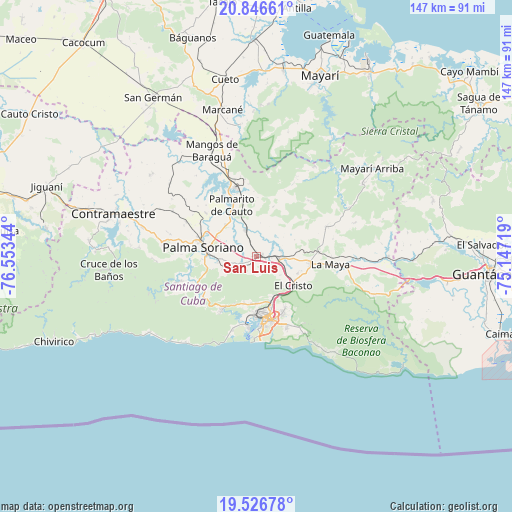
San Luis GPS coordinates[2]
20° 11' 17.124" North, 75° 51' 1.116" West
| Map corner | latitude | longitude |
|---|---|---|
| Upper-left | 20.84661°, | -76.55344° |
| Center: | 20.18809°, | -75.85031° |
| Lower-right: | 19.52678°, | -75.14719° |
| Map W x H: | 146.8×146.8 km | = 91.2×91.2mi |
| max Lat: | 23.15917° ⇑94.5% North |
| San Luis: | 20.18809° |
| min Lat: | ⇓5.5% South 19.90553° |
| min Long | San Luis | max Long |
| -84.28599° | -75.85031° | -74.15181° |
| W 91.2%⇐ | ⇒8.8% E |
Elevation
Elevation of San Luis is 201 m = 659 ft, and this is 132.4 m = 434 ft above average elevation for this country.
| Max E: |
761 m = 2497 ft | 4.4% |
| San Luis | 201 m 659 ft | |
| Avg. | 68.6 m = 225 ft | |
Min E: |
3 m = 10 ft | 95.6% |
See also: San Luis elevation on elevation.city.
Geographical zone
San Luis is located in North Torrid zone (between Equator and Tropic of Cancer). Distance of this Northern Tropic circle is 361.2 km =224.4 mi to North.| Distance of | km | miles | from San Luis |
|---|---|---|---|
| North Pole | 7762.4 | 4823.3 | to North |
| Arctic Circle | 5156.5 | 3204.1 | to North |
| Tropic Cancer | 361.2 | 224.4 | to North |
| Equator | 2244.7 | 1394.8 | to South |


Nearby cities:
15 places around San Luis: (largest is in red/bold)
• Antilla
72.5 km =45 mi,  9°
9°
• Báguanos
65.2 km =40.5 mi,  343°
343°
• Cauto Cristo
76.8 km =47.7 mi,  302°
302°
• Contramaestre
43 km =26.7 mi,  286°
286°
• Cueto
51.9 km =32.2 mi,  350°
350°
• El Cobre
18.4 km =11.4 mi,  212°
212°
• Guantánamo
67.1 km =41.7 mi,  94°
94°
• Guisa
72.3 km =44.9 mi,  275°
275°
• Jiguaní
63.4 km =39.4 mi, 288°
• Mayarí
54.8 km =34.1 mi,  18°
18°
• Palma Soriano
15.2 km =9.4 mi, 279°
• Sagua de Tánamo
77.2 km =48 mi,  55°
55°
• San Germán
54.5 km =33.9 mi,  327°
327°
• Santiago de Cuba
18.8 km =11.7 mi,  172°
172°
• Segundo Frente
44.6 km =27.7 mi, 55°
Sources, notices
• [Note1] Compared only with cities in Cuba existing in our database
• [Src1] Map data: © OpenStreetMap contributors (CC-BY-SA)
• [Src2] Other city data from geonames.org with taken over terms of usage.
• [Src3] Geographical zone / Annual Mean Temperature by Robert A. Rohde @ Wikipedia
