Homburg geodata
Homburg (Saarland) is a seat of a third-order administrative division; located in Germany in Europe/Berlin (GMT+2) time zone. With population of 44,607 people, there are 267 cities with bigger population in this country. Compared to other cities in Germany, 78.2% of cities are located further ↑North; 89.4% of cities are located further →East and 52.3% of cities have lower elevation than Homburg. Note1


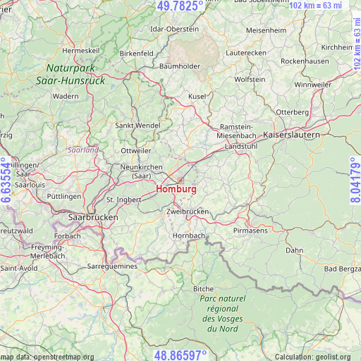
Homburg GPS coordinates[2]
49° 19' 34.932" North, 7° 20' 19.212" East
| Map corner | latitude | longitude |
|---|---|---|
| Upper-left | 49.7825°, | 6.63554° |
| Center: | 49.32637°, | 7.33867° |
| Lower-right: | 48.86597°, | 8.04179° |
| Map W x H: | 101.9×101.9 km | = 63.3×63.3mi |
| max Lat: | 55.01917° ⇑78.2% North |
| Homburg: | 49.32637° |
| min Lat: | ⇓21.8% South 47.40724° |
| min Long | Homburg | max Long |
| 5.92978° | 7.33867° | 14.98853° |
| W 10.6%⇐ | ⇒89.4% E |
Elevation
Elevation of Homburg is 242 m = 794 ft, and this is 7.1 m = 23 ft below average elevation for this country.
| Max E: |
1256 m = 4121 ft | 47.7% |
| Avg. | 249.1 m = 817 ft | |
| Homburg | 242 m = 794 ft | |
Min E: |
-5 m = -16 ft | 52.3% |
See also: Homburg elevation on elevation.city.
Geographical zone
Homburg is located in North temperate zone (between Tropic of Cancer and the Arctic Circle). Distance of this North polar circle is 1916.6 km =1190.9 mi to North.| Distance of | km | miles | from Homburg |
|---|---|---|---|
| North Pole | 4522.5 | 2810.2 | to North |
| Arctic Circle | 1916.6 | 1190.9 | to North |
| Tropic Cancer | 2878.7 | 1788.7 | to South |
| Equator | 5484.6 | 3408 | to South |


Nearby cities:
15 places around Homburg: (largest is in red/bold)
• Bechhofen
5.2 km =3.2 mi,  59°
59°
• Bexbach
6.4 km =4 mi,  290°
290°
• Bruchmühlbach-Miesau
9.3 km =5.8 mi,  47°
47°
• Großbundenbach
6.4 km =4 mi,  117°
117°
• Kirkel
9 km =5.6 mi,  237°
237°
• Kleinbundenbach
6.9 km =4.3 mi,  98°
98°
• Krähenberg
9.3 km =5.8 mi,  85°
85°
• Käshofen
5.7 km =3.5 mi,  82°
82°
• Lambsborn
8.2 km =5.1 mi, 56°
• Rosenkopf
7.3 km =4.5 mi,  69°
69°
• Schönenberg-Kübelberg
9.3 km =5.8 mi,  15°
15°
• Waldmohr
6.3 km =3.9 mi,  356°
356°
• Wiesbach
8.1 km =5 mi, 84°
• Winterbach
10.1 km =6.3 mi, 104°
• Zweibrücken
9.1 km =5.7 mi,  165°
165°
Sources, notices
• [Note1] Compared only with cities in Germany existing in our database
• [Src1] Map data: © OpenStreetMap contributors (CC-BY-SA)
• [Src2] Other city data from geonames.org with taken over terms of usage.
• [Src3] Geographical zone / Annual Mean Temperature by Robert A. Rohde @ Wikipedia
