Rosche geodata
Rosche (Lower Saxony) is a seat of a fourth-order administrative division; located in Germany in Europe/Berlin (GMT+2) time zone. With population of 2,157 people, there are 4859 cities with bigger population in this country. Compared to other cities in Germany, 81.7% of cities are located further ↓South; 63.3% of cities are located further ←West and 75.5% of cities have higher elevation than Rosche. Note1


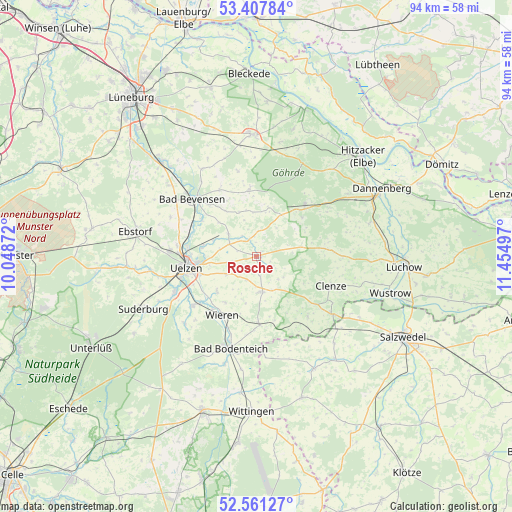
Rosche GPS coordinates[2]
52° 59' 11.868" North, 10° 45' 6.624" East
| Map corner | latitude | longitude |
|---|---|---|
| Upper-left | 53.40784°, | 10.04872° |
| Center: | 52.98663°, | 10.75184° |
| Lower-right: | 52.56127°, | 11.45497° |
| Map W x H: | 94.1×94.1 km | = 58.5×58.5mi |
| max Lat: | 55.01917° ⇑18.3% North |
| Rosche: | 52.98663° |
| min Lat: | ⇓81.7% South 47.40724° |
| min Long | Rosche | max Long |
| 5.92978° | 10.75184° | 14.98853° |
| W 63.3%⇐ | ⇒36.7% E |
Elevation
Elevation of Rosche is 61 m = 200 ft, and this is 188.1 m = 617 ft below average elevation for this country.
| Max E: |
1256 m = 4121 ft | 75.5% |
| Avg. | 249.1 m = 817 ft | |
| Rosche | 61 m = 200 ft | |
Min E: |
-5 m = -16 ft | 24.5% |
See also: Germany elevation on elevation.city.
Geographical zone
Rosche is located in North temperate zone (between Tropic of Cancer and the Arctic Circle). Distance of this North polar circle is 1509.6 km =938 mi to North.| Distance of | km | miles | from Rosche |
|---|---|---|---|
| North Pole | 4115.5 | 2557.3 | to North |
| Arctic Circle | 1509.6 | 938 | to North |
| Tropic Cancer | 3285.6 | 2041.6 | to South |
| Equator | 5891.6 | 3660.9 | to South |


Nearby cities:
15 places around Rosche: (largest is in red/bold)
• Clenze
14.8 km =9.2 mi,  111°
111°
• Emmendorf
13.1 km =8.1 mi,  286°
286°
• Himbergen
12.1 km =7.5 mi,  352°
352°
• Oetzen
6.2 km =3.9 mi,  305°
305°
• Rätzlingen
5.3 km =3.3 mi,  256°
256°
• Römstedt
14.3 km =8.9 mi,  331°
331°
• Schnega
14.2 km =8.8 mi,  138°
138°
• Soltendieck
12.6 km =7.8 mi,  177°
177°
• Stoetze
9.1 km =5.7 mi,  13°
13°
• Suhlendorf
6 km =3.7 mi,  170°
170°
• Uelzen
13 km =8.1 mi, 259°
• Waddeweitz
14.5 km =9 mi,  84°
84°
• Weste
8.7 km =5.4 mi,  337°
337°
• Wieren
12.9 km =8 mi,  208°
208°
• Zernien
12.6 km =7.8 mi,  44°
44°
Sources, notices
• [Note1] Compared only with cities in Germany existing in our database
• [Src1] Map data: © OpenStreetMap contributors (CC-BY-SA)
• [Src2] Other city data from geonames.org with taken over terms of usage.
• [Src3] Geographical zone / Annual Mean Temperature by Robert A. Rohde @ Wikipedia
