Wittmund geodata
Wittmund (Lower Saxony) is a seat of a third-order administrative division; located in Germany in Europe/Berlin (GMT+2) time zone. With population of 21,355 people, there are 714 cities with bigger population in this country. Compared to other cities in Germany, 86.6% of cities are located further ↓South; 81.4% of cities are located further →East and 97% of cities have higher elevation than Wittmund. Note1


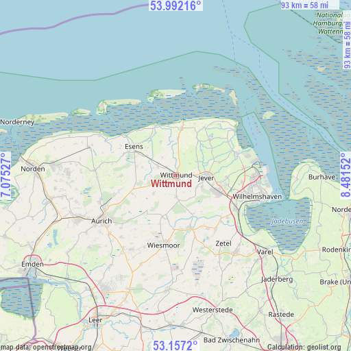
Wittmund GPS coordinates[2]
53° 34' 36.264" North, 7° 46' 42.204" East
| Map corner | latitude | longitude |
|---|---|---|
| Upper-left | 53.99216°, | 7.07527° |
| Center: | 53.57674°, | 7.77839° |
| Lower-right: | 53.1572°, | 8.48152° |
| Map W x H: | 92.8×92.8 km | = 57.7×57.7mi |
| max Lat: | 55.01917° ⇑13.4% North |
| Wittmund: | 53.57674° |
| min Lat: | ⇓86.6% South 47.40724° |
| min Long | Wittmund | max Long |
| 5.92978° | 7.77839° | 14.98853° |
| W 18.6%⇐ | ⇒81.4% E |
Elevation
Elevation of Wittmund is 4 m = 13 ft, and this is 245.1 m = 804 ft below average elevation for this country.
| Max E: |
1256 m = 4121 ft | 97% |
| Avg. | 249.1 m = 817 ft | |
| Wittmund | 4 m = 13 ft | |
Min E: |
-5 m = -16 ft | 3% |
See also: Germany elevation on elevation.city.
Geographical zone
Wittmund is located in North temperate zone (between Tropic of Cancer and the Arctic Circle). Distance of this North polar circle is 1444 km =897.3 mi to North.| Distance of | km | miles | from Wittmund |
|---|---|---|---|
| North Pole | 4049.9 | 2516.5 | to North |
| Arctic Circle | 1444 | 897.3 | to North |
| Tropic Cancer | 3351.3 | 2082.4 | to South |
| Equator | 5957.2 | 3701.6 | to South |


Nearby cities:
15 places around Wittmund: (largest is in red/bold)
• Bensersiel
17 km =10.6 mi,  308°
308°
• Blomberg
14.5 km =9 mi,  270°
270°
• Carolinensiel
12.8 km =8 mi,  6°
6°
• Dunum
8.9 km =5.5 mi,  286°
286°
• Esens
13.5 km =8.4 mi, 306°
• Friedeburg
14.6 km =9.1 mi,  165°
165°
• Holtgast
14.7 km =9.1 mi, 293°
• Jever
7.9 km =4.9 mi,  92°
92°
• Moorweg
14.3 km =8.9 mi,  296°
296°
• Neuharlingersiel
14.6 km =9.1 mi,  340°
340°
• Ostochtersum
16.9 km =10.5 mi,  281°
281°
• Schortens
12.3 km =7.6 mi,  113°
113°
• Sillenstede
13.6 km =8.5 mi, 91°
• Stedesdorf
9.7 km =6 mi, 310°
• Werdum
9.8 km =6.1 mi, 336°
Sources, notices
• [Note1] Compared only with cities in Germany existing in our database
• [Src1] Map data: © OpenStreetMap contributors (CC-BY-SA)
• [Src2] Other city data from geonames.org with taken over terms of usage.
• [Src3] Geographical zone / Annual Mean Temperature by Robert A. Rohde @ Wikipedia
