Jever geodata
Jever (Lower Saxony) is a seat of a third-order administrative division; located in Germany in Europe/Berlin (GMT+2) time zone. With population of 13,937 people, there are 1144 cities with bigger population in this country. Compared to other cities in Germany, 86.5% of cities are located further ↓South; 79% of cities are located further →East and 94.3% of cities have higher elevation than Jever. Note1


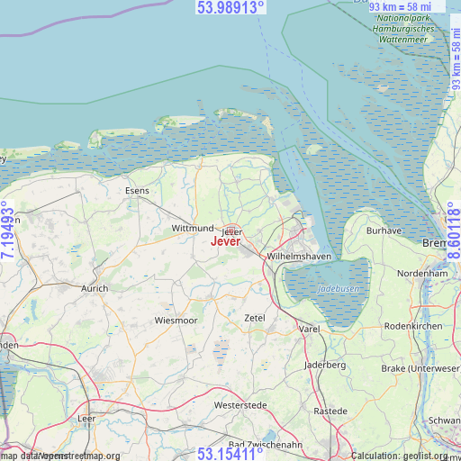
Jever GPS coordinates[2]
53° 34' 25.248" North, 7° 53' 53.016" East
| Map corner | latitude | longitude |
|---|---|---|
| Upper-left | 53.98913°, | 7.19493° |
| Center: | 53.57368°, | 7.89806° |
| Lower-right: | 53.15411°, | 8.60118° |
| Map W x H: | 92.8×92.8 km | = 57.7×57.7mi |
| max Lat: | 55.01917° ⇑13.5% North |
| Jever: | 53.57368° |
| min Lat: | ⇓86.5% South 47.40724° |
| min Long | Jever | max Long |
| 5.92978° | 7.89806° | 14.98853° |
| W 21%⇐ | ⇒79% E |
Elevation
Elevation of Jever is 10 m = 33 ft, and this is 239.1 m = 784 ft below average elevation for this country.
| Max E: |
1256 m = 4121 ft | 94.3% |
| Avg. | 249.1 m = 817 ft | |
| Jever | 10 m = 33 ft | |
Min E: |
-5 m = -16 ft | 5.7% |
See also: Germany elevation on elevation.city.
Geographical zone
Jever is located in North temperate zone (between Tropic of Cancer and the Arctic Circle). Distance of this North polar circle is 1444.3 km =897.4 mi to North.| Distance of | km | miles | from Jever |
|---|---|---|---|
| North Pole | 4050.2 | 2516.7 | to North |
| Arctic Circle | 1444.3 | 897.4 | to North |
| Tropic Cancer | 3350.9 | 2082.2 | to South |
| Equator | 5956.8 | 3701.4 | to South |


Nearby cities:
15 places around Jever: (largest is in red/bold)
• Carolinensiel
14.5 km =9 mi,  333°
333°
• Dunum
16.6 km =10.3 mi,  280°
280°
• Fedderwarden
9.7 km =6 mi,  98°
98°
• Friedeburg
14.4 km =8.9 mi,  197°
197°
• Neuharlingersiel
19 km =11.8 mi,  317°
317°
• Sande
10.8 km =6.7 mi,  134°
134°
• Schillig
16.6 km =10.3 mi,  29°
29°
• Schortens
5.6 km =3.5 mi,  142°
142°
• Sillenstede
5.7 km =3.5 mi,  89°
89°
• Stedesdorf
16.6 km =10.3 mi,  293°
293°
• Werdum
15 km =9.3 mi,  308°
308°
• Wiesmoor
20.6 km =12.8 mi,  211°
211°
• Wilhelmshaven
15 km =9.3 mi,  108°
108°
• Wittmund
7.9 km =4.9 mi,  272°
272°
• Zetel
18.3 km =11.4 mi,  162°
162°
Sources, notices
• [Note1] Compared only with cities in Germany existing in our database
• [Src1] Map data: © OpenStreetMap contributors (CC-BY-SA)
• [Src2] Other city data from geonames.org with taken over terms of usage.
• [Src3] Geographical zone / Annual Mean Temperature by Robert A. Rohde @ Wikipedia
