Ottrau geodata
Ottrau (Hesse) is a seat of a fourth-order administrative division; located in Germany in Europe/Berlin (GMT+2) time zone. With population of 2,496 people, there are 4445 cities with bigger population in this country. Compared to other cities in Germany, 54.3% of cities are located further ↓South; 59.5% of cities are located further →East and 67.6% of cities have lower elevation than Ottrau. Note1
Administrative division(s):
- Level 1: Hesse
- Level 2: Regierungsbezirk Kassel
- Level 3: Schwalm-Eder-Kreis
- Level 4: Ottrau


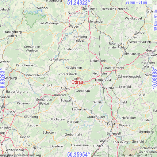
Ottrau GPS coordinates[2]
50° 48' 21.564" North, 9° 23' 8.7" East
| Map corner | latitude | longitude |
|---|---|---|
| Upper-left | 51.24822°, | 8.68263° |
| Center: | 50.80599°, | 9.38575° |
| Lower-right: | 50.35954°, | 10.08888° |
| Map W x H: | 98.8×98.8 km | = 61.4×61.4mi |
| max Lat: | 55.01917° ⇑45.7% North |
| Ottrau: | 50.80599° |
| min Lat: | ⇓54.3% South 47.40724° |
| min Long | Ottrau | max Long |
| 5.92978° | 9.38575° | 14.98853° |
| W 40.5%⇐ | ⇒59.5% E |
Elevation
Elevation of Ottrau is 340 m = 1115 ft, and this is 90.9 m = 298 ft above average elevation for this country.
| Max E: |
1256 m = 4121 ft | 32.4% |
| Ottrau | 340 m 1115 ft | |
| Avg. | 249.1 m = 817 ft | |
Min E: |
-5 m = -16 ft | 67.6% |
See also: Germany elevation on elevation.city.
Geographical zone
Ottrau is located in North temperate zone (between Tropic of Cancer and the Arctic Circle). Distance of this North polar circle is 1752.1 km =1088.7 mi to North.| Distance of | km | miles | from Ottrau |
|---|---|---|---|
| North Pole | 4358 | 2707.9 | to North |
| Arctic Circle | 1752.1 | 1088.7 | to North |
| Tropic Cancer | 3043.2 | 1891 | to South |
| Equator | 5649.1 | 3510.2 | to South |


Nearby cities:
15 places around Ottrau: (largest is in red/bold)
• Alsfeld
10.1 km =6.3 mi,  233°
233°
• Frielendorf
18.8 km =11.7 mi,  346°
346°
• Grebenau
9.4 km =5.8 mi,  139°
139°
• Kirchheim
13.1 km =8.1 mi,  76°
76°
• Neukirchen
7.5 km =4.7 mi,  338°
338°
• Niederaula
15.1 km =9.4 mi,  92°
92°
• Oberaula
7.5 km =4.7 mi,  49°
49°
• Riebelsdorf
9.7 km =6 mi,  325°
325°
• Romrod
15.5 km =9.6 mi, 228°
• Schrecksbach
7.8 km =4.8 mi,  292°
292°
• Schwalmstadt
18.5 km =11.5 mi,  320°
320°
• Schwalmtal
18.1 km =11.2 mi,  221°
221°
• Schwarzenborn
12.3 km =7.6 mi,  20°
20°
• Seigertshausen
11.9 km =7.4 mi, 350°
• Willingshausen
13.9 km =8.6 mi, 290°
Sources, notices
• [Note1] Compared only with cities in Germany existing in our database
• [Src1] Map data: © OpenStreetMap contributors (CC-BY-SA)
• [Src2] Other city data from geonames.org with taken over terms of usage.
• [Src3] Geographical zone / Annual Mean Temperature by Robert A. Rohde @ Wikipedia
