Langenzenn geodata
Langenzenn (Bavaria) is a populated place; located in Germany in Europe/Berlin (GMT+1) time zone. With population of 10,629 people, there are 1556 cities with bigger population in this country. Compared to other cities in Germany, 75.8% of cities are located further ↑North; 63.9% of cities are located further ←West and 62.7% of cities have lower elevation than Langenzenn. Note1
Administrative division(s):
- Level 1: Bavaria
- Level 2: Regierungsbezirk Mittelfranken
- Level 3: Landkreis Fürth
- Level 4: Langenzenn


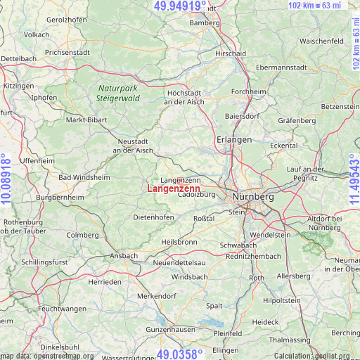
Langenzenn GPS coordinates[2]
49° 29' 40.668" North, 10° 47' 32.28" East
| Map corner | latitude | longitude |
|---|---|---|
| Upper-left | 49.94919°, | 10.08918° |
| Center: | 49.49463°, | 10.7923° |
| Lower-right: | 49.0358°, | 11.49543° |
| Map W x H: | 101.6×101.6 km | = 63.1×63.1mi |
| max Lat: | 55.01917° ⇑75.8% North |
| Langenzenn: | 49.49463° |
| min Lat: | ⇓24.2% South 47.40724° |
| min Long | Langenzenn | max Long |
| 5.92978° | 10.7923° | 14.98853° |
| W 63.9%⇐ | ⇒36.1% E |
Elevation
Elevation of Langenzenn is 306 m = 1004 ft, and this is 56.9 m = 187 ft above average elevation for this country.
| Max E: |
1256 m = 4121 ft | 37.3% |
| Langenzenn | 306 m 1004 ft | |
| Avg. | 249.1 m = 817 ft | |
Min E: |
-5 m = -16 ft | 62.7% |
See also: Germany elevation on elevation.city.
Geographical zone
Langenzenn is located in North temperate zone (between Tropic of Cancer and the Arctic Circle). Distance of this North polar circle is 1897.9 km =1179.3 mi to North.| Distance of | km | miles | from Langenzenn |
|---|---|---|---|
| North Pole | 4503.8 | 2798.5 | to North |
| Arctic Circle | 1897.9 | 1179.3 | to North |
| Tropic Cancer | 2897.4 | 1800.4 | to South |
| Equator | 5503.3 | 3419.6 | to South |


Nearby cities:
15 places around Langenzenn: (largest is in red/bold)
• Adelsdorf
8.2 km =5.1 mi,  250°
250°
• Ammerndorf
9 km =5.6 mi,  152°
152°
• Cadolzburg
6.1 km =3.8 mi,  133°
133°
• Emskirchen
8.6 km =5.3 mi,  318°
318°
• Großhabersdorf
10.5 km =6.5 mi,  183°
183°
• Hagenbüchach
4.7 km =2.9 mi,  336°
336°
• Herzogenaurach
10.6 km =6.6 mi,  39°
39°
• Markt Erlbach
10.1 km =6.3 mi,  269°
269°
• Obermichelbach
9.3 km =5.8 mi,  64°
64°
• Puschendorf
4.3 km =2.7 mi, 41°
• Seukendorf
6.4 km =4 mi,  96°
96°
• Tuchenbach
6.1 km =3.8 mi,  52°
52°
• Veitsbronn
7.2 km =4.5 mi,  74°
74°
• Wilhelmsdorf
8.7 km =5.4 mi,  332°
332°
• Wilhermsdorf
5.7 km =3.5 mi,  256°
256°
Sources, notices
• [Note1] Compared only with cities in Germany existing in our database
• [Src1] Map data: © OpenStreetMap contributors (CC-BY-SA)
• [Src2] Other city data from geonames.org with taken over terms of usage.
• [Src3] Geographical zone / Annual Mean Temperature by Robert A. Rohde @ Wikipedia
