Wiesmoor geodata
Wiesmoor (Lower Saxony) is a seat of a fourth-order administrative division; located in Germany in Europe/Berlin (GMT+2) time zone. With population of 13,157 people, there are 1218 cities with bigger population in this country. Compared to other cities in Germany, 84.7% of cities are located further ↓South; 82.5% of cities are located further →East and 92.3% of cities have higher elevation than Wiesmoor. Note1


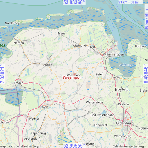
Wiesmoor GPS coordinates[2]
53° 25' 0.012" North, 7° 43' 59.988" East
| Map corner | latitude | longitude |
|---|---|---|
| Upper-left | 53.83366°, | 7.03021° |
| Center: | 53.41667°, | 7.73333° |
| Lower-right: | 52.99555°, | 8.43646° |
| Map W x H: | 93.2×93.2 km | = 57.9×57.9mi |
| max Lat: | 55.01917° ⇑15.3% North |
| Wiesmoor: | 53.41667° |
| min Lat: | ⇓84.7% South 47.40724° |
| min Long | Wiesmoor | max Long |
| 5.92978° | 7.73333° | 14.98853° |
| W 17.5%⇐ | ⇒82.5% E |
Elevation
Elevation of Wiesmoor is 15 m = 49 ft, and this is 234.1 m = 768 ft below average elevation for this country.
| Max E: |
1256 m = 4121 ft | 92.3% |
| Avg. | 249.1 m = 817 ft | |
| Wiesmoor | 15 m = 49 ft | |
Min E: |
-5 m = -16 ft | 7.7% |
See also: Germany elevation on elevation.city.
Geographical zone
Wiesmoor is located in North temperate zone (between Tropic of Cancer and the Arctic Circle). Distance of this North polar circle is 1461.8 km =908.3 mi to North.| Distance of | km | miles | from Wiesmoor |
|---|---|---|---|
| North Pole | 4067.7 | 2527.6 | to North |
| Arctic Circle | 1461.8 | 908.3 | to North |
| Tropic Cancer | 3333.5 | 2071.3 | to South |
| Equator | 5939.4 | 3690.6 | to South |


Nearby cities:
15 places around Wiesmoor: (largest is in red/bold)
• Aurich
17.6 km =10.9 mi,  289°
289°
• Bockhorn
18.9 km =11.7 mi,  95°
95°
• Brinkum
20 km =12.4 mi,  213°
213°
• Filsum
20.6 km =12.8 mi,  199°
199°
• Firrel
10.3 km =6.4 mi, 205°
• Friedeburg
7.6 km =4.7 mi,  60°
60°
• Hesel
15.7 km =9.8 mi, 214°
• Holtland
17.9 km =11.1 mi, 213°
• Jever
20.6 km =12.8 mi,  31°
31°
• Mittegroßefehn
11.4 km =7.1 mi,  255°
255°
• Neukamperfehn
14.5 km =9 mi,  231°
231°
• Schortens
19.3 km =12 mi,  47°
47°
• Schwerinsdorf
12.8 km =8 mi, 202°
• Wittmund
18 km =11.2 mi,  9°
9°
• Zetel
16.6 km =10.3 mi,  90°
90°
Sources, notices
• [Note1] Compared only with cities in Germany existing in our database
• [Src1] Map data: © OpenStreetMap contributors (CC-BY-SA)
• [Src2] Other city data from geonames.org with taken over terms of usage.
• [Src3] Geographical zone / Annual Mean Temperature by Robert A. Rohde @ Wikipedia
