Brey geodata
Brey (Rheinland-Pfalz) is a seat of a fourth-order administrative division; located in Germany in Europe/Berlin (GMT+2) time zone. With population of 1,596 people, there are 5694 cities with bigger population in this country. Compared to other cities in Germany, 57.3% of cities are located further ↑North; 84.5% of cities are located further →East and 69.7% of cities have higher elevation than Brey. Note1


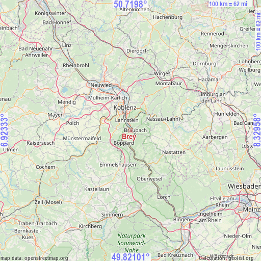
Brey GPS coordinates[2]
50° 16' 21.108" North, 7° 37' 35.22" East
| Map corner | latitude | longitude |
|---|---|---|
| Upper-left | 50.7198°, | 6.92333° |
| Center: | 50.27253°, | 7.62645° |
| Lower-right: | 49.82101°, | 8.32958° |
| Map W x H: | 99.9×99.9 km | = 62.1×62.1mi |
| max Lat: | 55.01917° ⇑57.3% North |
| Brey: | 50.27253° |
| min Lat: | ⇓42.7% South 47.40724° |
| min Long | Brey | max Long |
| 5.92978° | 7.62645° | 14.98853° |
| W 15.5%⇐ | ⇒84.5% E |
Elevation
Elevation of Brey is 93 m = 305 ft, and this is 156.1 m = 512 ft below average elevation for this country.
| Max E: |
1256 m = 4121 ft | 69.7% |
| Avg. | 249.1 m = 817 ft | |
| Brey | 93 m = 305 ft | |
Min E: |
-5 m = -16 ft | 30.3% |
See also: Germany elevation on elevation.city.
Geographical zone
Brey is located in North temperate zone (between Tropic of Cancer and the Arctic Circle). Distance of this North polar circle is 1811.4 km =1125.6 mi to North.| Distance of | km | miles | from Brey |
|---|---|---|---|
| North Pole | 4417.3 | 2744.8 | to North |
| Arctic Circle | 1811.4 | 1125.6 | to North |
| Tropic Cancer | 2983.9 | 1854.1 | to South |
| Equator | 5589.8 | 3473.3 | to South |


Nearby cities:
15 places around Brey: (largest is in red/bold)
• Becheln
6.9 km =4.3 mi,  70°
70°
• Boppard
5.3 km =3.3 mi,  209°
209°
• Braubach
1.3 km =0.8 mi,  84°
84°
• Dachsenhausen
7.5 km =4.7 mi,  105°
105°
• Fachbach
7.9 km =4.9 mi,  30°
30°
• Filsen
4.7 km =2.9 mi,  219°
219°
• Frücht
6.4 km =4 mi,  39°
39°
• Kamp-Bornhofen
5.5 km =3.4 mi,  182°
182°
• Lahnstein
3.1 km =1.9 mi,  347°
347°
• Miellen
7.3 km =4.5 mi,  22°
22°
• Nievern
7.9 km =4.9 mi, 30°
• Osterspai
3.3 km =2.1 mi,  197°
197°
• Rhens
1.2 km =0.7 mi,  326°
326°
• Spay
2.2 km =1.4 mi,  134°
134°
• Waldesch
5.6 km =3.5 mi,  282°
282°
Sources, notices
• [Note1] Compared only with cities in Germany existing in our database
• [Src1] Map data: © OpenStreetMap contributors (CC-BY-SA)
• [Src2] Other city data from geonames.org with taken over terms of usage.
• [Src3] Geographical zone / Annual Mean Temperature by Robert A. Rohde @ Wikipedia
