Rhens geodata
Rhens (Rheinland-Pfalz) is a populated place; located in Germany in Europe/Berlin (GMT+2) time zone. With population of 3,016 people, there are 3984 cities with bigger population in this country. Compared to other cities in Germany, 57.2% of cities are located further ↑North; 84.5% of cities are located further →East and 71.7% of cities have higher elevation than Rhens. Note1
Administrative division(s):
- Level 1: Rheinland-Pfalz
- Level 3: Landkreis Mayen-Koblenz
- Level 4: Rhens


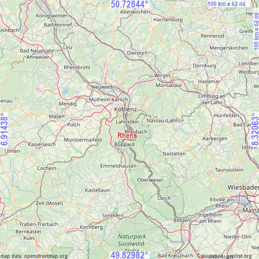
Rhens GPS coordinates[2]
50° 16' 52.5" North, 7° 37' 3" East
| Map corner | latitude | longitude |
|---|---|---|
| Upper-left | 50.72844°, | 6.91438° |
| Center: | 50.28125°, | 7.6175° |
| Lower-right: | 49.82982°, | 8.32063° |
| Map W x H: | 99.9×99.9 km | = 62.1×62.1mi |
| max Lat: | 55.01917° ⇑57.2% North |
| Rhens: | 50.28125° |
| min Lat: | ⇓42.8% South 47.40724° |
| min Long | Rhens | max Long |
| 5.92978° | 7.6175° | 14.98853° |
| W 15.5%⇐ | ⇒84.5% E |
Elevation
Elevation of Rhens is 80 m = 262 ft, and this is 169.1 m = 555 ft below average elevation for this country.
| Max E: |
1256 m = 4121 ft | 71.7% |
| Avg. | 249.1 m = 817 ft | |
| Rhens | 80 m = 262 ft | |
Min E: |
-5 m = -16 ft | 28.3% |
See also: Germany elevation on elevation.city.
Geographical zone
Rhens is located in North temperate zone (between Tropic of Cancer and the Arctic Circle). Distance of this North polar circle is 1810.4 km =1124.9 mi to North.| Distance of | km | miles | from Rhens |
|---|---|---|---|
| North Pole | 4416.3 | 2744.2 | to North |
| Arctic Circle | 1810.4 | 1124.9 | to North |
| Tropic Cancer | 2984.8 | 1854.7 | to South |
| Equator | 5590.8 | 3474 | to South |


Nearby cities:
15 places around Rhens: (largest is in red/bold)
• Becheln
7.3 km =4.5 mi,  79°
79°
• Boppard
5.9 km =3.7 mi,  199°
199°
• Braubach
2.1 km =1.3 mi,  113°
113°
• Brey
1.2 km =0.7 mi,  146°
146°
• Fachbach
7.4 km =4.6 mi,  38°
38°
• Filsen
5.1 km =3.2 mi,  206°
206°
• Frücht
6.1 km =3.8 mi,  49°
49°
• Kamp-Bornhofen
6.5 km =4 mi,  176°
176°
• Lahnstein
2.1 km =1.3 mi,  358°
358°
• Miellen
6.8 km =4.2 mi,  31°
31°
• Nievern
7.4 km =4.6 mi, 38°
• Osterspai
4.1 km =2.5 mi,  185°
185°
• Spay
3.3 km =2.1 mi,  138°
138°
• Waldesch
4.8 km =3 mi,  272°
272°
• Winningen
8.2 km =5.1 mi,  298°
298°
Sources, notices
• [Note1] Compared only with cities in Germany existing in our database
• [Src1] Map data: © OpenStreetMap contributors (CC-BY-SA)
• [Src2] Other city data from geonames.org with taken over terms of usage.
• [Src3] Geographical zone / Annual Mean Temperature by Robert A. Rohde @ Wikipedia
