Osterspai geodata
Osterspai (Rheinland-Pfalz) is a seat of a fourth-order administrative division; located in Germany in Europe/Berlin (GMT+2) time zone. With population of 1,351 people, there are 6180 cities with bigger population in this country. Compared to other cities in Germany, 58% of cities are located further ↑North; 84.8% of cities are located further →East and 70.7% of cities have higher elevation than Osterspai. Note1


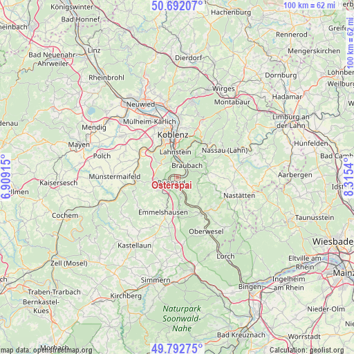
Osterspai GPS coordinates[2]
50° 14' 40.308" North, 7° 36' 44.172" East
| Map corner | latitude | longitude |
|---|---|---|
| Upper-left | 50.69207°, | 6.90915° |
| Center: | 50.24453°, | 7.61227° |
| Lower-right: | 49.79275°, | 8.3154° |
| Map W x H: | 100×100 km | = 62.1×62.1mi |
| max Lat: | 55.01917° ⇑58% North |
| Osterspai: | 50.24453° |
| min Lat: | ⇓42% South 47.40724° |
| min Long | Osterspai | max Long |
| 5.92978° | 7.61227° | 14.98853° |
| W 15.2%⇐ | ⇒84.8% E |
Elevation
Elevation of Osterspai is 87 m = 285 ft, and this is 162.1 m = 532 ft below average elevation for this country.
| Max E: |
1256 m = 4121 ft | 70.7% |
| Avg. | 249.1 m = 817 ft | |
| Osterspai | 87 m = 285 ft | |
Min E: |
-5 m = -16 ft | 29.3% |
See also: Germany elevation on elevation.city.
Geographical zone
Osterspai is located in North temperate zone (between Tropic of Cancer and the Arctic Circle). Distance of this North polar circle is 1814.5 km =1127.5 mi to North.| Distance of | km | miles | from Osterspai |
|---|---|---|---|
| North Pole | 4420.4 | 2746.7 | to North |
| Arctic Circle | 1814.5 | 1127.5 | to North |
| Tropic Cancer | 2980.7 | 1852.1 | to South |
| Equator | 5586.7 | 3471.4 | to South |


Nearby cities:
15 places around Osterspai: (largest is in red/bold)
• Boppard
2.2 km =1.4 mi,  226°
226°
• Braubach
4 km =2.5 mi,  35°
35°
• Brey
3.3 km =2.1 mi,  17°
17°
• Dachsenhausen
8.2 km =5.1 mi,  82°
82°
• Dahlheim
7.1 km =4.4 mi,  122°
122°
• Filsen
2 km =1.2 mi,  256°
256°
• Kamp-Bornhofen
2.5 km =1.6 mi,  161°
161°
• Kestert
7.3 km =4.5 mi, 158°
• Kratzenburg
8.1 km =5 mi,  213°
213°
• Lahnstein
6.2 km =3.9 mi,  2°
2°
• Lykershausen
6.3 km =3.9 mi,  141°
141°
• Prath
7.4 km =4.6 mi, 136°
• Rhens
4.1 km =2.5 mi,  5°
5°
• Spay
3 km =1.9 mi,  58°
58°
• Waldesch
6.2 km =3.9 mi,  314°
314°
Sources, notices
• [Note1] Compared only with cities in Germany existing in our database
• [Src1] Map data: © OpenStreetMap contributors (CC-BY-SA)
• [Src2] Other city data from geonames.org with taken over terms of usage.
• [Src3] Geographical zone / Annual Mean Temperature by Robert A. Rohde @ Wikipedia
