Spay geodata
Spay (Rheinland-Pfalz) is a seat of a fourth-order administrative division; located in Germany in Europe/Berlin (GMT+2) time zone. With population of 2,056 people, there are 4991 cities with bigger population in this country. Compared to other cities in Germany, 57.6% of cities are located further ↑North; 84% of cities are located further →East and 72.6% of cities have higher elevation than Spay. Note1


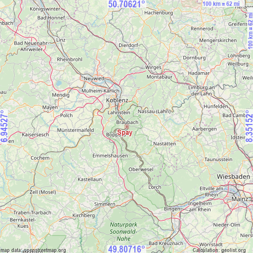
Spay GPS coordinates[2]
50° 15' 31.716" North, 7° 38' 54.204" East
| Map corner | latitude | longitude |
|---|---|---|
| Upper-left | 50.70621°, | 6.94527° |
| Center: | 50.25881°, | 7.64839° |
| Lower-right: | 49.80716°, | 8.35152° |
| Map W x H: | 100×100 km | = 62.1×62.1mi |
| max Lat: | 55.01917° ⇑57.6% North |
| Spay: | 50.25881° |
| min Lat: | ⇓42.4% South 47.40724° |
| min Long | Spay | max Long |
| 5.92978° | 7.64839° | 14.98853° |
| W 16%⇐ | ⇒84% E |
Elevation
Elevation of Spay is 74 m = 243 ft, and this is 175.1 m = 574 ft below average elevation for this country.
| Max E: |
1256 m = 4121 ft | 72.6% |
| Avg. | 249.1 m = 817 ft | |
| Spay | 74 m = 243 ft | |
Min E: |
-5 m = -16 ft | 27.4% |
See also: Germany elevation on elevation.city.
Geographical zone
Spay is located in North temperate zone (between Tropic of Cancer and the Arctic Circle). Distance of this North polar circle is 1812.9 km =1126.5 mi to North.| Distance of | km | miles | from Spay |
|---|---|---|---|
| North Pole | 4418.8 | 2745.7 | to North |
| Arctic Circle | 1812.9 | 1126.5 | to North |
| Tropic Cancer | 2982.3 | 1853.1 | to South |
| Equator | 5588.3 | 3472.4 | to South |


Nearby cities:
15 places around Spay: (largest is in red/bold)
• Becheln
6.2 km =3.9 mi,  52°
52°
• Boppard
5.2 km =3.2 mi,  233°
233°
• Braubach
1.7 km =1.1 mi,  351°
351°
• Brey
2.2 km =1.4 mi,  314°
314°
• Dachsenhausen
5.6 km =3.5 mi,  95°
95°
• Dahlheim
6.4 km =4 mi,  148°
148°
• Filsen
5 km =3.1 mi,  245°
245°
• Frücht
6.9 km =4.3 mi,  21°
21°
• Kamp-Bornhofen
4.4 km =2.7 mi,  203°
203°
• Lahnstein
5.1 km =3.2 mi,  333°
333°
• Lykershausen
6.7 km =4.2 mi,  168°
168°
• Oberbachheim
7.2 km =4.5 mi, 101°
• Osterspai
3 km =1.9 mi,  238°
238°
• Rhens
3.3 km =2.1 mi,  318°
318°
• Winterwerb
6.9 km =4.3 mi,  111°
111°
Sources, notices
• [Note1] Compared only with cities in Germany existing in our database
• [Src1] Map data: © OpenStreetMap contributors (CC-BY-SA)
• [Src2] Other city data from geonames.org with taken over terms of usage.
• [Src3] Geographical zone / Annual Mean Temperature by Robert A. Rohde @ Wikipedia
