Suhlendorf geodata
Suhlendorf (Lower Saxony) is a seat of a fourth-order administrative division; located in Germany in Europe/Berlin (GMT+2) time zone. With population of 2,661 people, there are 4267 cities with bigger population in this country. Compared to other cities in Germany, 81.3% of cities are located further ↓South; 63.5% of cities are located further ←West and 75.3% of cities have higher elevation than Suhlendorf. Note1


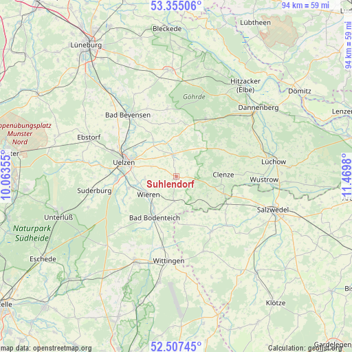
Suhlendorf GPS coordinates[2]
52° 55' 59.988" North, 10° 46' 0.012" East
| Map corner | latitude | longitude |
|---|---|---|
| Upper-left | 53.35506°, | 10.06355° |
| Center: | 52.93333°, | 10.76667° |
| Lower-right: | 52.50745°, | 11.4698° |
| Map W x H: | 94.2×94.2 km | = 58.5×58.5mi |
| max Lat: | 55.01917° ⇑18.7% North |
| Suhlendorf: | 52.93333° |
| min Lat: | ⇓81.3% South 47.40724° |
| min Long | Suhlendorf | max Long |
| 5.92978° | 10.76667° | 14.98853° |
| W 63.5%⇐ | ⇒36.5% E |
Elevation
Elevation of Suhlendorf is 62 m = 203 ft, and this is 187.1 m = 614 ft below average elevation for this country.
| Max E: |
1256 m = 4121 ft | 75.3% |
| Avg. | 249.1 m = 817 ft | |
| Suhlendorf | 62 m = 203 ft | |
Min E: |
-5 m = -16 ft | 24.7% |
See also: Germany elevation on elevation.city.
Geographical zone
Suhlendorf is located in North temperate zone (between Tropic of Cancer and the Arctic Circle). Distance of this North polar circle is 1515.5 km =941.7 mi to North.| Distance of | km | miles | from Suhlendorf |
|---|---|---|---|
| North Pole | 4121.4 | 2560.9 | to North |
| Arctic Circle | 1515.5 | 941.7 | to North |
| Tropic Cancer | 3279.7 | 2037.9 | to South |
| Equator | 5885.6 | 3657.1 | to South |


Nearby cities:
15 places around Suhlendorf: (largest is in red/bold)
• Bergen an der Dumme
13.6 km =8.5 mi,  110°
110°
• Bodenteich
12.7 km =7.9 mi,  206°
206°
• Clenze
12.8 km =8 mi,  88°
88°
• Lüder
15.4 km =9.6 mi, 205°
• Oetzen
11.3 km =7 mi,  327°
327°
• Rosche
6 km =3.7 mi,  350°
350°
• Rätzlingen
7.7 km =4.8 mi,  307°
307°
• Schnega
9.6 km =6 mi,  119°
119°
• Soltendieck
6.6 km =4.1 mi,  182°
182°
• Stoetze
14.9 km =9.3 mi,  4°
4°
• Uelzen
14.2 km =8.8 mi,  284°
284°
• Waddeweitz
15.3 km =9.5 mi,  61°
61°
• Weste
14.7 km =9.1 mi,  343°
343°
• Wieren
9 km =5.6 mi,  233°
233°
• Wrestedt
13.3 km =8.3 mi,  255°
255°
Sources, notices
• [Note1] Compared only with cities in Germany existing in our database
• [Src1] Map data: © OpenStreetMap contributors (CC-BY-SA)
• [Src2] Other city data from geonames.org with taken over terms of usage.
• [Src3] Geographical zone / Annual Mean Temperature by Robert A. Rohde @ Wikipedia
