Bad Arolsen geodata
Bad Arolsen (Hesse) is a populated place; located in Germany in Europe/Berlin (GMT+2) time zone. With population of 16,854 people, there are 938 cities with bigger population in this country. Compared to other cities in Germany, 64.4% of cities are located further ↓South; 65.2% of cities are located further →East and 60.4% of cities have lower elevation than Bad Arolsen. Note1
Administrative division(s):
- Level 1: Hesse
- Level 2: Regierungsbezirk Kassel
- Level 3: Landkreis Waldeck-Frankenberg
- Level 4: Bad Arolsen


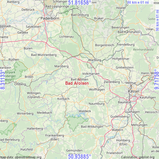
Bad Arolsen GPS coordinates[2]
51° 22' 47.352" North, 9° 0' 52.02" East
| Map corner | latitude | longitude |
|---|---|---|
| Upper-left | 51.81658°, | 8.31133° |
| Center: | 51.37982°, | 9.01445° |
| Lower-right: | 50.93885°, | 9.71758° |
| Map W x H: | 97.6×97.6 km | = 60.6×60.6mi |
| max Lat: | 55.01917° ⇑35.6% North |
| Bad Arolsen: | 51.37982° |
| min Lat: | ⇓64.4% South 47.40724° |
| min Long | Bad Arolsen | max Long |
| 5.92978° | 9.01445° | 14.98853° |
| W 34.8%⇐ | ⇒65.2% E |
Elevation
Elevation of Bad Arolsen is 292 m = 958 ft, and this is 42.9 m = 141 ft above average elevation for this country.
| Max E: |
1256 m = 4121 ft | 39.6% |
| Bad Arolsen | 292 m 958 ft | |
| Avg. | 249.1 m = 817 ft | |
Min E: |
-5 m = -16 ft | 60.4% |
See also: Germany elevation on elevation.city.
Geographical zone
Bad Arolsen is located in North temperate zone (between Tropic of Cancer and the Arctic Circle). Distance of this North polar circle is 1688.3 km =1049.1 mi to North.| Distance of | km | miles | from Bad Arolsen |
|---|---|---|---|
| North Pole | 4294.2 | 2668.3 | to North |
| Arctic Circle | 1688.3 | 1049.1 | to North |
| Tropic Cancer | 3107 | 1930.6 | to South |
| Equator | 5712.9 | 3549.8 | to South |


Nearby cities:
15 places around Bad Arolsen: (largest is in red/bold)
• Breuna
12.5 km =7.8 mi,  71°
71°
• Hemfurth-Edersee
22.8 km =14.2 mi,  172°
172°
• Korbach
15.2 km =9.4 mi,  220°
220°
• Liebenau
22.7 km =14.1 mi,  54°
54°
• Marsberg
14.6 km =9.1 mi,  308°
308°
• Martinhagen
21.5 km =13.4 mi,  118°
118°
• Naumburg
18 km =11.2 mi,  144°
144°
• Rhoden
10.4 km =6.5 mi,  358°
358°
• Sachsenhausen
15.2 km =9.4 mi,  181°
181°
• Volkmarsen
7.9 km =4.9 mi, 65°
• Vöhl
20 km =12.4 mi,  193°
193°
• Waldeck
19.6 km =12.2 mi, 170°
• Warburg
15.3 km =9.5 mi,  36°
36°
• Wolfhagen
12.4 km =7.7 mi, 118°
• Zierenberg
20 km =12.4 mi,  93°
93°
Sources, notices
• [Note1] Compared only with cities in Germany existing in our database
• [Src1] Map data: © OpenStreetMap contributors (CC-BY-SA)
• [Src2] Other city data from geonames.org with taken over terms of usage.
• [Src3] Geographical zone / Annual Mean Temperature by Robert A. Rohde @ Wikipedia
