Uthlede geodata
Uthlede (Lower Saxony) is a seat of a fourth-order administrative division; located in Germany in Europe/Berlin (GMT+2) time zone. With population of 1,020 people, there are 7118 cities with bigger population in this country. Compared to other cities in Germany, 83.8% of cities are located further ↓South; 70.4% of cities are located further →East and 95.2% of cities have higher elevation than Uthlede. Note1
Administrative division(s):
- Level 1: Lower Saxony
- Level 3: Landkreis Cuxhaven
- Level 4: Hagen im Bremischen


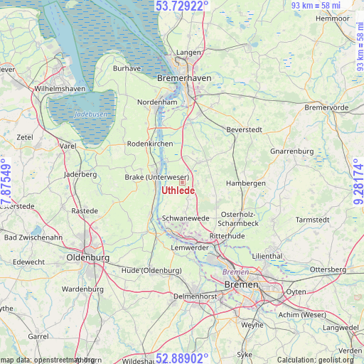
Uthlede GPS coordinates[2]
53° 18' 40.284" North, 8° 34' 42.996" East
| Map corner | latitude | longitude |
|---|---|---|
| Upper-left | 53.72922°, | 7.87549° |
| Center: | 53.31119°, | 8.57861° |
| Lower-right: | 52.88902°, | 9.28174° |
| Map W x H: | 93.4×93.4 km | = 58×58mi |
| max Lat: | 55.01917° ⇑16.2% North |
| Uthlede: | 53.31119° |
| min Lat: | ⇓83.8% South 47.40724° |
| min Long | Uthlede | max Long |
| 5.92978° | 8.57861° | 14.98853° |
| W 29.6%⇐ | ⇒70.4% E |
Elevation
Elevation of Uthlede is 8 m = 26 ft, and this is 241.1 m = 791 ft below average elevation for this country.
| Max E: |
1256 m = 4121 ft | 95.2% |
| Avg. | 249.1 m = 817 ft | |
| Uthlede | 8 m = 26 ft | |
Min E: |
-5 m = -16 ft | 4.8% |
See also: Germany elevation on elevation.city.
Geographical zone
Uthlede is located in North temperate zone (between Tropic of Cancer and the Arctic Circle). Distance of this North polar circle is 1473.5 km =915.6 mi to North.| Distance of | km | miles | from Uthlede |
|---|---|---|---|
| North Pole | 4079.4 | 2534.8 | to North |
| Arctic Circle | 1473.5 | 915.6 | to North |
| Tropic Cancer | 3321.7 | 2064 | to South |
| Equator | 5927.6 | 3683.2 | to South |


Nearby cities:
15 places around Uthlede: (largest is in red/bold)
• Axstedt
13.9 km =8.6 mi,  69°
69°
• Bokel
15.5 km =9.6 mi,  54°
54°
• Brake (Unterweser)
6.8 km =4.2 mi,  291°
291°
• Bramstedt
9.6 km =6 mi, 50°
• Driftsethe
8.4 km =5.2 mi,  17°
17°
• Elsfleth
11.5 km =7.1 mi,  224°
224°
• Hagen im Bremischen
6.7 km =4.2 mi,  40°
40°
• Hollen
15.2 km =9.4 mi,  33°
33°
• Lübberstedt
14.9 km =9.3 mi,  80°
80°
• Neuenkirchen
9.5 km =5.9 mi,  201°
201°
• Ovelgönne
11 km =6.8 mi, 288°
• Sandstedt
6.6 km =4.1 mi,  324°
324°
• Schwanewede
8.8 km =5.5 mi,  170°
170°
• Vegesack
16.3 km =10.1 mi, 171°
• Wulsbüttel
5.9 km =3.7 mi, 84°
Sources, notices
• [Note1] Compared only with cities in Germany existing in our database
• [Src1] Map data: © OpenStreetMap contributors (CC-BY-SA)
• [Src2] Other city data from geonames.org with taken over terms of usage.
• [Src3] Geographical zone / Annual Mean Temperature by Robert A. Rohde @ Wikipedia
