Schwanewede geodata
Schwanewede (Lower Saxony) is a seat of a fourth-order administrative division; located in Germany in Europe/Berlin (GMT+2) time zone. With population of 20,015 people, there are 778 cities with bigger population in this country. Compared to other cities in Germany, 83.1% of cities are located further ↓South; 70.2% of cities are located further →East and 93.5% of cities have higher elevation than Schwanewede. Note1


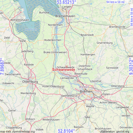
Schwanewede GPS coordinates[2]
53° 13' 59.988" North, 8° 36' 0" East
| Map corner | latitude | longitude |
|---|---|---|
| Upper-left | 53.65213°, | 7.89687° |
| Center: | 53.23333°, | 8.6° |
| Lower-right: | 52.8104°, | 9.30312° |
| Map W x H: | 93.6×93.6 km | = 58.2×58.2mi |
| max Lat: | 55.01917° ⇑16.9% North |
| Schwanewede: | 53.23333° |
| min Lat: | ⇓83.1% South 47.40724° |
| min Long | Schwanewede | max Long |
| 5.92978° | 8.6° | 14.98853° |
| W 29.8%⇐ | ⇒70.2% E |
Elevation
Elevation of Schwanewede is 12 m = 39 ft, and this is 237.1 m = 778 ft below average elevation for this country.
| Max E: |
1256 m = 4121 ft | 93.5% |
| Avg. | 249.1 m = 817 ft | |
| Schwanewede | 12 m = 39 ft | |
Min E: |
-5 m = -16 ft | 6.5% |
See also: Germany elevation on elevation.city.
Geographical zone
Schwanewede is located in North temperate zone (between Tropic of Cancer and the Arctic Circle). Distance of this North polar circle is 1482.2 km =921 mi to North.| Distance of | km | miles | from Schwanewede |
|---|---|---|---|
| North Pole | 4088.1 | 2540.2 | to North |
| Arctic Circle | 1482.2 | 921 | to North |
| Tropic Cancer | 3313.1 | 2058.7 | to South |
| Equator | 5919 | 3677.9 | to South |


Nearby cities:
15 places around Schwanewede: (largest is in red/bold)
• Brake (Unterweser)
13.6 km =8.5 mi,  325°
325°
• Bramstedt
15.9 km =9.9 mi,  22°
22°
• Burglesum
9.6 km =6 mi,  141°
141°
• Driftsethe
16.7 km =10.4 mi,  3°
3°
• Elsfleth
9.6 km =6 mi,  272°
272°
• Hagen im Bremischen
14.1 km =8.8 mi,  11°
11°
• Hude
16.7 km =10.4 mi,  213°
213°
• Lemwerder
7.5 km =4.7 mi,  171°
171°
• Neuenkirchen
4.9 km =3 mi, 267°
• Osterholz-Scharmbeck
13 km =8.1 mi,  93°
93°
• Ritterhude
10.6 km =6.6 mi,  121°
121°
• Sandstedt
15 km =9.3 mi,  339°
339°
• Uthlede
8.8 km =5.5 mi,  350°
350°
• Vegesack
7.5 km =4.7 mi, 171°
• Wulsbüttel
10.3 km =6.4 mi,  25°
25°
Sources, notices
• [Note1] Compared only with cities in Germany existing in our database
• [Src1] Map data: © OpenStreetMap contributors (CC-BY-SA)
• [Src2] Other city data from geonames.org with taken over terms of usage.
• [Src3] Geographical zone / Annual Mean Temperature by Robert A. Rohde @ Wikipedia
