Sandstedt geodata
Sandstedt (Lower Saxony) is a seat of a fourth-order administrative division; located in Germany in Europe/Berlin (GMT+2) time zone. With population of 1,808 people, there are 5335 cities with bigger population in this country. Compared to other cities in Germany, 84.2% of cities are located further ↓South; 70.9% of cities are located further →East and 99.1% of cities have higher elevation than Sandstedt. Note1
Administrative division(s):
- Level 1: Lower Saxony
- Level 3: Landkreis Cuxhaven
- Level 4: Hagen im Bremischen


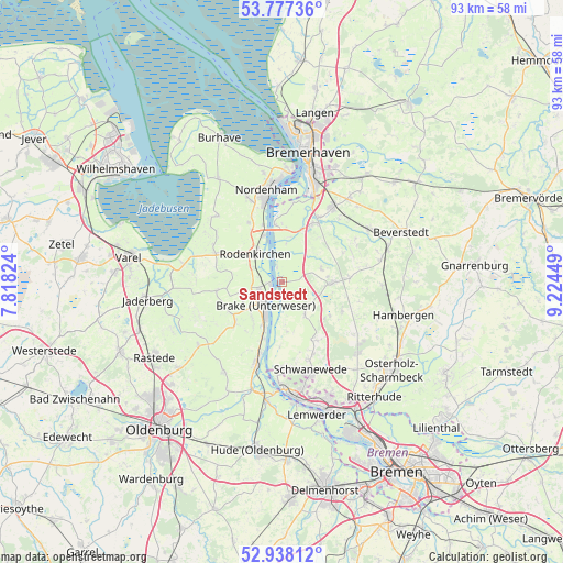
Sandstedt GPS coordinates[2]
53° 21' 35.316" North, 8° 31' 16.932" East
| Map corner | latitude | longitude |
|---|---|---|
| Upper-left | 53.77736°, | 7.81824° |
| Center: | 53.35981°, | 8.52137° |
| Lower-right: | 52.93812°, | 9.22449° |
| Map W x H: | 93.3×93.3 km | = 58×58mi |
| max Lat: | 55.01917° ⇑15.8% North |
| Sandstedt: | 53.35981° |
| min Lat: | ⇓84.2% South 47.40724° |
| min Long | Sandstedt | max Long |
| 5.92978° | 8.52137° | 14.98853° |
| W 29.1%⇐ | ⇒70.9% E |
Elevation
Elevation of Sandstedt is 0 m = 0 ft, and this is 249.1 m = 817 ft below average elevation for this country.
| Max E: |
1256 m = 4121 ft | 99.1% |
| Avg. | 249.1 m = 817 ft | |
| Sandstedt | 0 m = 0 ft | |
Min E: |
-5 m = -16 ft | 0.9% |
See also: Germany elevation on elevation.city.
Geographical zone
Sandstedt is located in North temperate zone (between Tropic of Cancer and the Arctic Circle). Distance of this North polar circle is 1468.1 km =912.2 mi to North.| Distance of | km | miles | from Sandstedt |
|---|---|---|---|
| North Pole | 4074 | 2531.5 | to North |
| Arctic Circle | 1468.1 | 912.2 | to North |
| Tropic Cancer | 3327.1 | 2067.4 | to South |
| Equator | 5933.1 | 3686.7 | to South |


Nearby cities:
15 places around Sandstedt: (largest is in red/bold)
• Axstedt
16.8 km =10.4 mi,  91°
91°
• Bokel
16.8 km =10.4 mi,  77°
77°
• Brake (Unterweser)
3.9 km =2.4 mi,  220°
220°
• Bramstedt
11.2 km =7 mi, 86°
• Driftsethe
6.8 km =4.2 mi,  67°
67°
• Elsfleth
14.3 km =8.9 mi,  197°
197°
• Hagen im Bremischen
8.1 km =5 mi, 92°
• Hollen
14.1 km =8.8 mi,  59°
59°
• Loxstedt
14.6 km =9.1 mi,  35°
35°
• Neuenkirchen
14.2 km =8.8 mi,  178°
178°
• Nordenham
14.3 km =8.9 mi,  349°
349°
• Ovelgönne
6.9 km =4.3 mi,  253°
253°
• Schwanewede
15 km =9.3 mi,  159°
159°
• Uthlede
6.6 km =4.1 mi,  144°
144°
• Wulsbüttel
10.8 km =6.7 mi,  116°
116°
Sources, notices
• [Note1] Compared only with cities in Germany existing in our database
• [Src1] Map data: © OpenStreetMap contributors (CC-BY-SA)
• [Src2] Other city data from geonames.org with taken over terms of usage.
• [Src3] Geographical zone / Annual Mean Temperature by Robert A. Rohde @ Wikipedia
