Brake (Unterweser) geodata
Brake (Unterweser) (Lower Saxony) is a seat of a third-order administrative division; located in Germany in Europe/Berlin (GMT+2) time zone. With population of 16,150 people, there are 987 cities with bigger population in this country. Compared to other cities in Germany, 83.9% of cities are located further ↓South; 71.2% of cities are located further →East and 99.1% of cities have higher elevation than Brake (Unterweser). Note1
Administrative division(s):
- Level 1: Lower Saxony
- Level 3: Landkreis Wesermarsch
- Level 4: Brake (Unterweser)


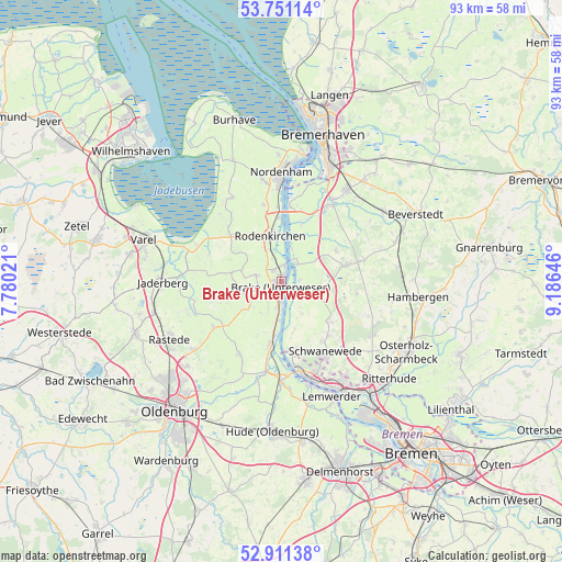
Brake (Unterweser) GPS coordinates[2]
53° 19' 59.988" North, 8° 28' 59.988" East
| Map corner | latitude | longitude |
|---|---|---|
| Upper-left | 53.75114°, | 7.78021° |
| Center: | 53.33333°, | 8.48333° |
| Lower-right: | 52.91138°, | 9.18646° |
| Map W x H: | 93.4×93.4 km | = 58×58mi |
| max Lat: | 55.01917° ⇑16.1% North |
| Brake (Unterweser): | 53.33333° |
| min Lat: | ⇓83.9% South 47.40724° |
| min Long | Brake (Unterwes | max Long |
| 5.92978° | 8.48333° | 14.98853° |
| W 28.8%⇐ | ⇒71.2% E |
Elevation
Elevation of Brake (Unterweser) is 0 m = 0 ft, and this is 249.1 m = 817 ft below average elevation for this country.
| Max E: |
1256 m = 4121 ft | 99.1% |
| Avg. | 249.1 m = 817 ft | |
| Brake (Unterweser) | 0 m = 0 ft | |
Min E: |
-5 m = -16 ft | 0.9% |
See also: Germany elevation on elevation.city.
Geographical zone
Brake (Unterweser) is located in North temperate zone (between Tropic of Cancer and the Arctic Circle). Distance of this North polar circle is 1471.1 km =914.1 mi to North.| Distance of | km | miles | from Brake (Unterweser) |
|---|---|---|---|
| North Pole | 4077 | 2533.3 | to North |
| Arctic Circle | 1471.1 | 914.1 | to North |
| Tropic Cancer | 3324.2 | 2065.6 | to South |
| Equator | 5930.1 | 3684.8 | to South |


Nearby cities:
15 places around Brake (Unterweser): (largest is in red/bold)
• Axstedt
19.5 km =12.1 mi,  83°
83°
• Bokel
20 km =12.4 mi,  70°
70°
• Bramstedt
14.2 km =8.8 mi, 75°
• Driftsethe
10.4 km =6.5 mi,  57°
57°
• Elsfleth
10.8 km =6.7 mi,  189°
189°
• Hagen im Bremischen
10.9 km =6.8 mi, 76°
• Hollen
17.9 km =11.1 mi, 55°
• Loxstedt
18.5 km =11.5 mi,  36°
36°
• Neuenkirchen
11.7 km =7.3 mi,  165°
165°
• Nordenham
17 km =10.6 mi,  359°
359°
• Ovelgönne
4.2 km =2.6 mi,  283°
283°
• Sandstedt
3.9 km =2.4 mi, 40°
• Schwanewede
13.6 km =8.5 mi,  145°
145°
• Uthlede
6.8 km =4.2 mi,  111°
111°
• Wulsbüttel
12.3 km =7.6 mi,  98°
98°
Sources, notices
• [Note1] Compared only with cities in Germany existing in our database
• [Src1] Map data: © OpenStreetMap contributors (CC-BY-SA)
• [Src2] Other city data from geonames.org with taken over terms of usage.
• [Src3] Geographical zone / Annual Mean Temperature by Robert A. Rohde @ Wikipedia
