Elsfleth geodata
Elsfleth (Lower Saxony) is a populated place; located in Germany in Europe/Berlin (GMT+2) time zone. With population of 9,310 people, there are 1733 cities with bigger population in this country. Compared to other cities in Germany, 83.2% of cities are located further ↓South; 71.5% of cities are located further →East and 97.6% of cities have higher elevation than Elsfleth. Note1


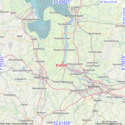
Elsfleth GPS coordinates[2]
53° 14' 14.928" North, 8° 27' 23.904" East
| Map corner | latitude | longitude |
|---|---|---|
| Upper-left | 53.65623°, | 7.75351° |
| Center: | 53.23748°, | 8.45664° |
| Lower-right: | 52.81459°, | 9.15976° |
| Map W x H: | 93.6×93.6 km | = 58.2×58.2mi |
| max Lat: | 55.01917° ⇑16.8% North |
| Elsfleth: | 53.23748° |
| min Lat: | ⇓83.2% South 47.40724° |
| min Long | Elsfleth | max Long |
| 5.92978° | 8.45664° | 14.98853° |
| W 28.5%⇐ | ⇒71.5% E |
Elevation
Elevation of Elsfleth is 3 m = 10 ft, and this is 246.1 m = 807 ft below average elevation for this country.
| Max E: |
1256 m = 4121 ft | 97.6% |
| Avg. | 249.1 m = 817 ft | |
| Elsfleth | 3 m = 10 ft | |
Min E: |
-5 m = -16 ft | 2.4% |
See also: Germany elevation on elevation.city.
Geographical zone
Elsfleth is located in North temperate zone (between Tropic of Cancer and the Arctic Circle). Distance of this North polar circle is 1481.7 km =920.7 mi to North.| Distance of | km | miles | from Elsfleth |
|---|---|---|---|
| North Pole | 4087.6 | 2539.9 | to North |
| Arctic Circle | 1481.7 | 920.7 | to North |
| Tropic Cancer | 3313.5 | 2058.9 | to South |
| Equator | 5919.5 | 3678.2 | to South |


Nearby cities:
15 places around Elsfleth: (largest is in red/bold)
• Brake (Unterweser)
10.8 km =6.7 mi,  9°
9°
• Burglesum
17.4 km =10.8 mi,  117°
117°
• Driftsethe
19.4 km =12.1 mi,  33°
33°
• Hagen im Bremischen
18.2 km =11.3 mi,  43°
43°
• Hude
14.4 km =8.9 mi,  178°
178°
• Lemwerder
13.3 km =8.3 mi,  126°
126°
• Neuenkirchen
4.7 km =2.9 mi,  97°
97°
• Oldenburg
19.4 km =12.1 mi,  236°
236°
• Ovelgönne
11.8 km =7.3 mi,  348°
348°
• Rastede
17.1 km =10.6 mi,  274°
274°
• Sandstedt
14.3 km =8.9 mi,  17°
17°
• Schwanewede
9.6 km =6 mi,  92°
92°
• Uthlede
11.5 km =7.1 mi, 44°
• Vegesack
13.3 km =8.3 mi, 126°
• Wulsbüttel
16.5 km =10.3 mi,  57°
57°
Sources, notices
• [Note1] Compared only with cities in Germany existing in our database
• [Src1] Map data: © OpenStreetMap contributors (CC-BY-SA)
• [Src2] Other city data from geonames.org with taken over terms of usage.
• [Src3] Geographical zone / Annual Mean Temperature by Robert A. Rohde @ Wikipedia
