Berga geodata
Berga (Saxony-Anhalt) is a seat of a fourth-order administrative division; located in Germany in Europe/Berlin (GMT+2) time zone. With population of 1,920 people, there are 5180 cities with bigger population in this country. Compared to other cities in Germany, 65.6% of cities are located further ↓South; 67.1% of cities are located further ←West and 59.1% of cities have higher elevation than Berga. Note1


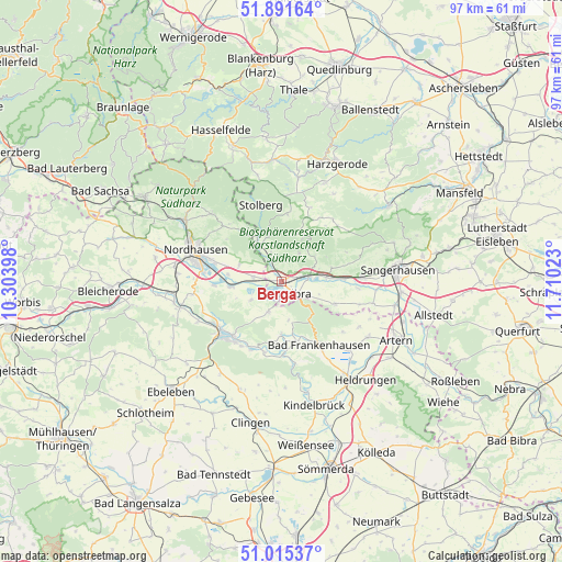
Berga GPS coordinates[2]
51° 27' 20.196" North, 11° 0' 25.56" East
| Map corner | latitude | longitude |
|---|---|---|
| Upper-left | 51.89164°, | 10.30398° |
| Center: | 51.45561°, | 11.0071° |
| Lower-right: | 51.01537°, | 11.71023° |
| Map W x H: | 97.4×97.4 km | = 60.5×60.5mi |
| max Lat: | 55.01917° ⇑34.4% North |
| Berga: | 51.45561° |
| min Lat: | ⇓65.6% South 47.40724° |
| min Long | Berga | max Long |
| 5.92978° | 11.0071° | 14.98853° |
| W 67.1%⇐ | ⇒32.9% E |
Elevation
Elevation of Berga is 160 m = 525 ft, and this is 89.1 m = 292 ft below average elevation for this country.
| Max E: |
1256 m = 4121 ft | 59.1% |
| Avg. | 249.1 m = 817 ft | |
| Berga | 160 m = 525 ft | |
Min E: |
-5 m = -16 ft | 40.9% |
See also: Germany elevation on elevation.city.
Geographical zone
Berga is located in North temperate zone (between Tropic of Cancer and the Arctic Circle). Distance of this North polar circle is 1679.8 km =1043.8 mi to North.| Distance of | km | miles | from Berga |
|---|---|---|---|
| North Pole | 4285.7 | 2663 | to North |
| Arctic Circle | 1679.8 | 1043.8 | to North |
| Tropic Cancer | 3115.4 | 1935.8 | to South |
| Equator | 5721.3 | 3555 | to South |


Nearby cities:
15 places around Berga: (largest is in red/bold)
• Auleben
6.3 km =3.9 mi,  238°
238°
• Badra
5.9 km =3.7 mi,  202°
202°
• Bendeleben
9.2 km =5.7 mi,  180°
180°
• Bennungen
7.7 km =4.8 mi,  85°
85°
• Breitungen
5.6 km =3.5 mi,  33°
33°
• Görsbach
4.9 km =3 mi,  278°
278°
• Heringen
9.1 km =5.7 mi,  264°
264°
• Kelbra
3.3 km =2.1 mi,  133°
133°
• Rottleberode
7.9 km =4.9 mi,  328°
328°
• Roßla
4.8 km =3 mi,  79°
79°
• Steinthaleben
6.8 km =4.2 mi,  169°
169°
• Tilleda
10.1 km =6.3 mi,  113°
113°
• Uftrungen
5.1 km =3.2 mi,  339°
339°
• Urbach
7.8 km =4.8 mi,  290°
290°
• Windehausen
9.4 km =5.8 mi, 276°
Sources, notices
• [Note1] Compared only with cities in Germany existing in our database
• [Src1] Map data: © OpenStreetMap contributors (CC-BY-SA)
• [Src2] Other city data from geonames.org with taken over terms of usage.
• [Src3] Geographical zone / Annual Mean Temperature by Robert A. Rohde @ Wikipedia
