Radibor geodata
Radibor (Saxony) is a seat of a fourth-order administrative division; located in Germany in Europe/Berlin (GMT+2) time zone. With population of 3,651 people, there are 3508 cities with bigger population in this country. Compared to other cities in Germany, 62.3% of cities are located further ↓South; 99.1% of cities are located further ←West and 58% of cities have higher elevation than Radibor. Note1


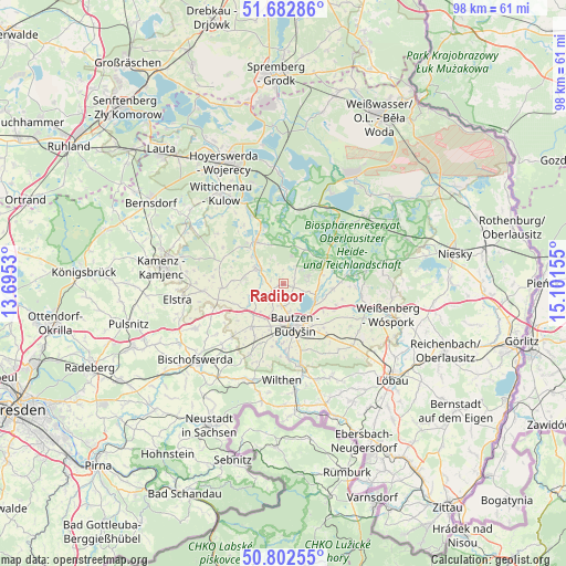
Radibor GPS coordinates[2]
51° 14' 41.316" North, 14° 23' 54.312" East
| Map corner | latitude | longitude |
|---|---|---|
| Upper-left | 51.68286°, | 13.6953° |
| Center: | 51.24481°, | 14.39842° |
| Lower-right: | 50.80255°, | 15.10155° |
| Map W x H: | 97.9×97.9 km | = 60.8×60.8mi |
| max Lat: | 55.01917° ⇑37.7% North |
| Radibor: | 51.24481° |
| min Lat: | ⇓62.3% South 47.40724° |
| min Long | Radibor | max Long |
| 5.92978° | 14.39842° | 14.98853° |
| W 99.1%⇐ | ⇒0.90000000000001% E |
Elevation
Elevation of Radibor is 168 m = 551 ft, and this is 81.1 m = 266 ft below average elevation for this country.
| Max E: |
1256 m = 4121 ft | 58% |
| Avg. | 249.1 m = 817 ft | |
| Radibor | 168 m = 551 ft | |
Min E: |
-5 m = -16 ft | 42% |
See also: Germany elevation on elevation.city.
Geographical zone
Radibor is located in North temperate zone (between Tropic of Cancer and the Arctic Circle). Distance of this North polar circle is 1703.3 km =1058.4 mi to North.| Distance of | km | miles | from Radibor |
|---|---|---|---|
| North Pole | 4309.2 | 2677.6 | to North |
| Arctic Circle | 1703.3 | 1058.4 | to North |
| Tropic Cancer | 3092 | 1921.3 | to South |
| Equator | 5697.9 | 3540.5 | to South |


Nearby cities:
15 places around Radibor: (largest is in red/bold)
• Bautzen
7.6 km =4.7 mi,  160°
160°
• Crostwitz
10.8 km =6.7 mi,  266°
266°
• Großdubrau
4.3 km =2.7 mi,  76°
76°
• Großpostwitz
14.1 km =8.8 mi,  167°
167°
• Guttau
11.4 km =7.1 mi, 82°
• Göda
9.2 km =5.7 mi,  216°
216°
• Horka
10.2 km =6.3 mi,  281°
281°
• Kubschütz
11.2 km =7 mi,  140°
140°
• Königswartha
8.8 km =5.5 mi,  326°
326°
• Malschwitz
8.6 km =5.3 mi,  95°
95°
• Neschwitz
5.6 km =3.5 mi,  300°
300°
• Obergurig
12.4 km =7.7 mi,  177°
177°
• Panschwitz-Kuckau
14 km =8.7 mi, 265°
• Puschwitz
6.9 km =4.3 mi, 279°
• Räckelwitz
11.5 km =7.1 mi, 272°
Sources, notices
• [Note1] Compared only with cities in Germany existing in our database
• [Src1] Map data: © OpenStreetMap contributors (CC-BY-SA)
• [Src2] Other city data from geonames.org with taken over terms of usage.
• [Src3] Geographical zone / Annual Mean Temperature by Robert A. Rohde @ Wikipedia
