Großdubrau geodata
Großdubrau (Saxony) is a seat of a fourth-order administrative division; located in Germany in Europe/Berlin (GMT+2) time zone. With population of 4,793 people, there are 2904 cities with bigger population in this country. Compared to other cities in Germany, 62.4% of cities are located further ↓South; 99.3% of cities are located further ←West and 54% of cities have higher elevation than Großdubrau. Note1


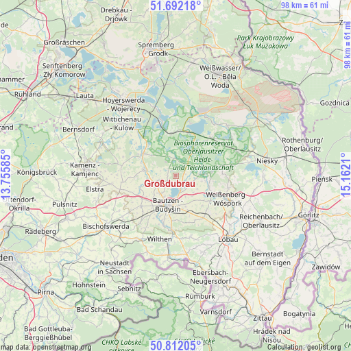
Großdubrau GPS coordinates[2]
51° 15' 15.192" North, 14° 27' 32.292" East
| Map corner | latitude | longitude |
|---|---|---|
| Upper-left | 51.69218°, | 13.75585° |
| Center: | 51.25422°, | 14.45897° |
| Lower-right: | 50.81205°, | 15.1621° |
| Map W x H: | 97.9×97.9 km | = 60.8×60.8mi |
| max Lat: | 55.01917° ⇑37.6% North |
| Großdubrau: | 51.25422° |
| min Lat: | ⇓62.4% South 47.40724° |
| min Long | Großdubrau | max Long |
| 5.92978° | 14.45897° | 14.98853° |
| W 99.3%⇐ | ⇒0.7% E |
Elevation
Elevation of Großdubrau is 197 m = 646 ft, and this is 52.1 m = 171 ft below average elevation for this country.
| Max E: |
1256 m = 4121 ft | 54% |
| Avg. | 249.1 m = 817 ft | |
| Großdubrau | 197 m = 646 ft | |
Min E: |
-5 m = -16 ft | 46% |
See also: Germany elevation on elevation.city.
Geographical zone
Großdubrau is located in North temperate zone (between Tropic of Cancer and the Arctic Circle). Distance of this North polar circle is 1702.2 km =1057.7 mi to North.| Distance of | km | miles | from Großdubrau |
|---|---|---|---|
| North Pole | 4308.1 | 2676.9 | to North |
| Arctic Circle | 1702.2 | 1057.7 | to North |
| Tropic Cancer | 3093 | 1921.9 | to South |
| Equator | 5698.9 | 3541.1 | to South |


Nearby cities:
15 places around Großdubrau: (largest is in red/bold)
• Bautzen
8.4 km =5.2 mi,  191°
191°
• Großpostwitz
14.9 km =9.3 mi,  184°
184°
• Guttau
7.1 km =4.4 mi,  85°
85°
• Göda
12.9 km =8 mi,  228°
228°
• Hochkirch
14.1 km =8.8 mi,  146°
146°
• Horka
14.2 km =8.8 mi,  274°
274°
• Klitten
14.8 km =9.2 mi,  43°
43°
• Kubschütz
10.1 km =6.3 mi,  163°
163°
• Königswartha
11 km =6.8 mi,  304°
304°
• Malschwitz
4.7 km =2.9 mi,  112°
112°
• Neschwitz
9.2 km =5.7 mi,  281°
281°
• Obergurig
14 km =8.7 mi,  195°
195°
• Puschwitz
11 km =6.8 mi, 270°
• Radibor
4.3 km =2.7 mi,  256°
256°
• Uhyst
12.7 km =7.9 mi,  14°
14°
Sources, notices
• [Note1] Compared only with cities in Germany existing in our database
• [Src1] Map data: © OpenStreetMap contributors (CC-BY-SA)
• [Src2] Other city data from geonames.org with taken over terms of usage.
• [Src3] Geographical zone / Annual Mean Temperature by Robert A. Rohde @ Wikipedia
